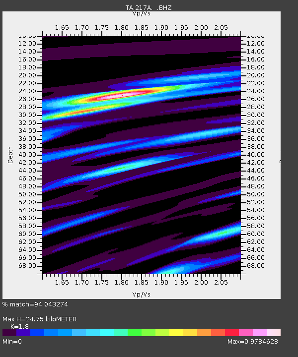
217A Green Valley, AZ, USA - Earthquake Result Viewer
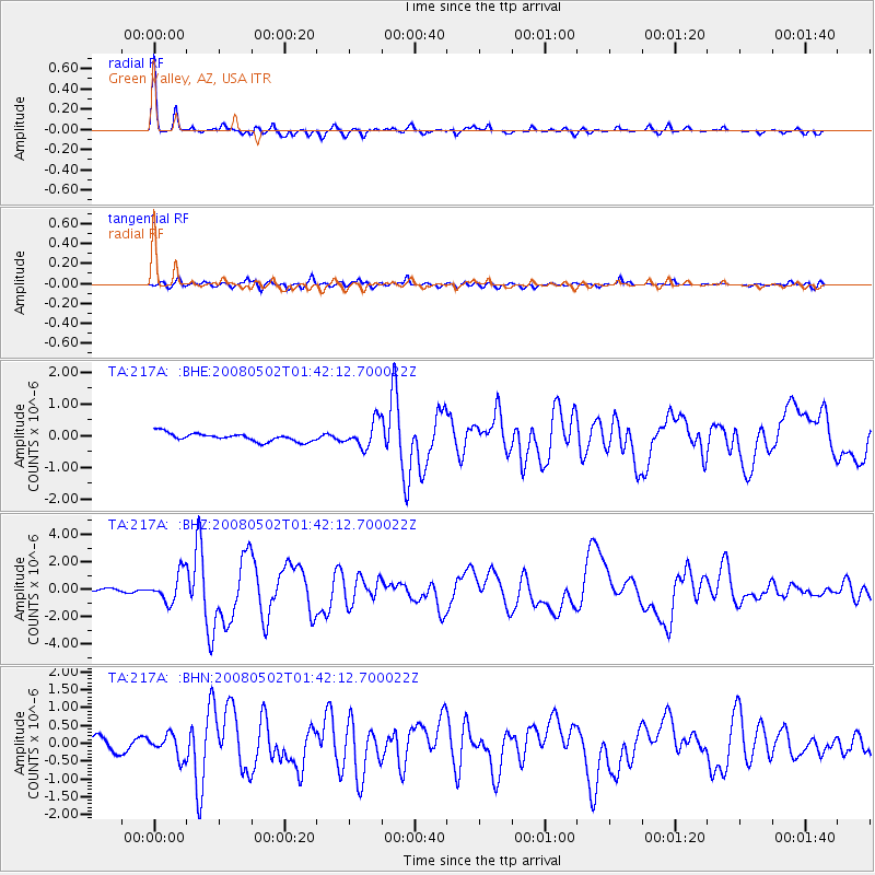
Earthquake location: Andreanof Islands, Aleutian Is.
Earthquake latitude/longitude: 51.9/-177.5
Earthquake time(UTC): 2008/05/02 (123) 01:33:37 GMT
Earthquake Depth: 14 km
Earthquake Magnitude: 6.3 MB, 6.8 MS, 6.6 MW, 6.6 MW
Earthquake Catalog/Contributor: WHDF/NEIC
Network: TA USArray Transportable Network (new EarthScope stations)
Station: 217A Green Valley, AZ, USA
Lat/Lon: 31.77 N/110.82 W
Elevation: 1412 m
Distance: 51.7 deg
Az: 85.558 deg
Baz: 313.458 deg
Ray Param: 0.06723882
Estimated Moho Depth: 24.75 km
Estimated Crust Vp/Vs: 1.80
Assumed Crust Vp: 6.264 km/s
Estimated Crust Vs: 3.48 km/s
Estimated Crust Poisson's Ratio: 0.28
Radial Match: 94.043274 %
Radial Bump: 339
Transverse Match: 76.7037 %
Transverse Bump: 400
SOD ConfigId: 2504
Insert Time: 2010-03-06 09:27:29.424 +0000
GWidth: 2.5
Max Bumps: 400
Tol: 0.001

Signal To Noise

ChannelStoNSTALTA
TA:217A: :BHZ:20080502T01:42:12.700022Z8.3418141.0585345E-61.26895E-7
TA:217A: :BHN:20080502T01:42:12.700022Z2.00144983.140927E-71.5693259E-7
TA:217A: :BHE:20080502T01:42:12.700022Z3.22642144.0857228E-71.2663327E-7
Arrivals
Ps3.3 SECOND
PpPs10 SECOND
PsPs/PpSs14 SECOND