You are here: Home > Network List > TA - USArray Transportable Network (new EarthScope stations) Stations List
> Station 217A Green Valley, AZ, USA > Earthquake Result Viewer
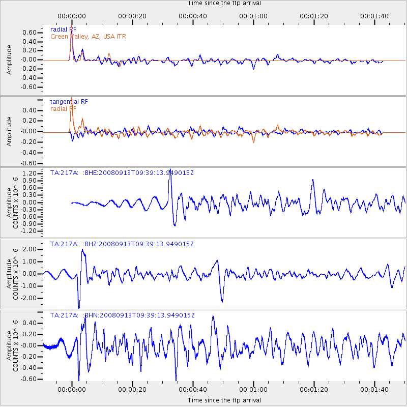
217A Green Valley, AZ, USA - Earthquake Result Viewer
*The percent match for this event was below the threshold and hence no stack was calculated.
| Earthquake location: |
Colombia |
| Earthquake latitude/longitude: |
4.8/-75.5 |
| Earthquake time(UTC): |
2008/09/13 (257) 09:32:01 GMT |
| Earthquake Depth: |
133 km |
| Earthquake Magnitude: |
5.9 MB, 5.7 MW, 5.7 MW |
| Earthquake Catalog/Contributor: |
WHDF/NEIC |
|
| Network: |
TA USArray Transportable Network (new EarthScope stations) |
| Station: |
217A Green Valley, AZ, USA |
| Lat/Lon: |
31.77 N/110.82 W |
| Elevation: |
1412 m |
|
| Distance: |
42.6 deg |
| Az: |
313.348 deg |
| Baz: |
121.693 deg |
| Ray Param: |
$rayparam |
*The percent match for this event was below the threshold and hence was not used in the summary stack. |
|
| Radial Match: |
78.77818 % |
| Radial Bump: |
365 |
| Transverse Match: |
71.16716 % |
| Transverse Bump: |
400 |
| SOD ConfigId: |
2504 |
| Insert Time: |
2010-03-06 09:28:18.189 +0000 |
| GWidth: |
2.5 |
| Max Bumps: |
400 |
| Tol: |
0.001 |
|
Signal To Noise
| Channel | StoN | STA | LTA |
| TA:217A: :BHZ:20080913T09:39:13.949015Z | 8.206872 | 1.2706903E-6 | 1.5483248E-7 |
| TA:217A: :BHN:20080913T09:39:13.949015Z | 6.1052117 | 2.7530788E-7 | 4.5093913E-8 |
| TA:217A: :BHE:20080913T09:39:13.949015Z | 6.367471 | 6.286566E-7 | 9.87294E-8 |
| Arrivals |
| Ps | |
| PpPs | |
| PsPs/PpSs | |


