You are here: Home > Network List > NM - Cooperative New Madrid Seismic Network Stations List
> Station FFIL Fairfield, IL > Earthquake Result Viewer
FFIL Fairfield, IL - Earthquake Result Viewer
| Earthquake location: |
Near Coast Of Ecuador |
| Earthquake latitude/longitude: |
0.6/-80.3 |
| Earthquake time(UTC): |
2016/04/23 (114) 01:24:34 GMT |
| Earthquake Depth: |
10 km |
| Earthquake Magnitude: |
5.8 MWP |
| Earthquake Catalog/Contributor: |
NEIC PDE/NEIC COMCAT |
|
| Network: |
NM Cooperative New Madrid Seismic Network |
| Station: |
FFIL Fairfield, IL |
| Lat/Lon: |
38.38 N/88.39 W |
| Elevation: |
446 m |
|
| Distance: |
38.3 deg |
| Az: |
349.689 deg |
| Baz: |
166.837 deg |
| Ray Param: |
0.07562355 |
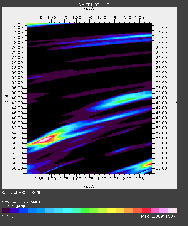
| Estimated Moho Depth: |
56.5 km |
| Estimated Crust Vp/Vs: |
1.67 |
| Assumed Crust Vp: |
6.444 km/s |
| Estimated Crust Vs: |
3.864 km/s |
| Estimated Crust Poisson's Ratio: |
0.22 |
|
| Radial Match: |
85.70829 % |
| Radial Bump: |
356 |
| Transverse Match: |
67.36918 % |
| Transverse Bump: |
400 |
| SOD ConfigId: |
1475611 |
| Insert Time: |
2016-05-07 01:30:29.111 +0000 |
| GWidth: |
2.5 |
| Max Bumps: |
400 |
| Tol: |
0.001 |
|

Signal To Noise
| Channel | StoN | STA | LTA |
| NM:FFIL:00:HHZ:20160423T01:31:24.028992Z | 5.8592434 | 9.037185E-7 | 1.5423808E-7 |
| NM:FFIL:00:HHN:20160423T01:31:24.028992Z | 3.5079982 | 6.805322E-7 | 1.9399445E-7 |
| NM:FFIL:00:HHE:20160423T01:31:24.028992Z | 0.5719249 | 1.1627001E-7 | 2.0329593E-7 |
| Arrivals |
| Ps | 6.3 SECOND |
| PpPs | 22 SECOND |
| PsPs/PpSs | 28 SECOND |


