You are here: Home > Network List > PS - Pacific21 Stations List
> Station PSI Parapat, Indonesia > Earthquake Result Viewer
PSI Parapat, Indonesia - Earthquake Result Viewer

| Earthquake location: |
New Guinea, Papua New Guinea |
| Earthquake latitude/longitude: |
-6.2/142.5 |
| Earthquake time(UTC): |
2018/02/28 (059) 02:45:44 GMT |
| Earthquake Depth: |
10 km |
| Earthquake Magnitude: |
6.0 Mww |
| Earthquake Catalog/Contributor: |
NEIC PDE/us |
|
| Network: |
PS Pacific21 |
| Station: |
PSI Parapat, Indonesia |
| Lat/Lon: |
2.69 N/98.92 E |
| Elevation: |
987 m |
|
| Distance: |
44.4 deg |
| Az: |
280.192 deg |
| Baz: |
101.576 deg |
| Ray Param: |
0.071958594 |
| Estimated Moho Depth: |
28.0 km |
| Estimated Crust Vp/Vs: |
1.60 |
| Assumed Crust Vp: |
6.468 km/s |
| Estimated Crust Vs: |
4.042 km/s |
| Estimated Crust Poisson's Ratio: |
0.18 |
|
| Radial Match: |
93.30325 % |
| Radial Bump: |
311 |
| Transverse Match: |
88.7853 % |
| Transverse Bump: |
355 |
| SOD ConfigId: |
13570011 |
| Insert Time: |
2019-04-29 21:29:11.986 +0000 |
| GWidth: |
2.5 |
| Max Bumps: |
400 |
| Tol: |
0.001 |
|
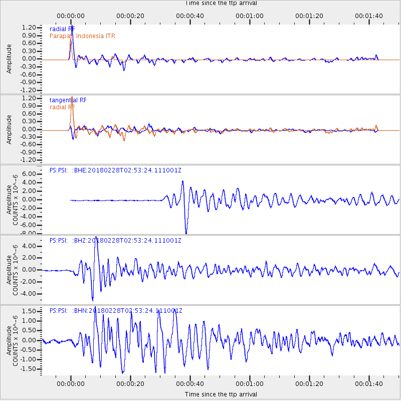
Signal To Noise
| Channel | StoN | STA | LTA |
| PS:PSI: :BHZ:20180228T02:53:24.111001Z | 21.63661 | 8.6426786E-7 | 3.9944698E-8 |
| PS:PSI: :BHN:20180228T02:53:24.111001Z | 5.1967506 | 2.6963093E-7 | 5.1884523E-8 |
| PS:PSI: :BHE:20180228T02:53:24.111001Z | 20.613668 | 8.077939E-7 | 3.91873E-8 |
| Arrivals |
| Ps | 2.8 SECOND |
| PpPs | 10 SECOND |
| PsPs/PpSs | 13 SECOND |


