You are here: Home > Network List > TA - USArray Transportable Network (new EarthScope stations) Stations List
> Station B18K Kokolik River, AK, USA > Earthquake Result Viewer
B18K Kokolik River, AK, USA - Earthquake Result Viewer
| Earthquake location: |
New Guinea, Papua New Guinea |
| Earthquake latitude/longitude: |
-6.2/142.5 |
| Earthquake time(UTC): |
2018/02/28 (059) 02:45:44 GMT |
| Earthquake Depth: |
10 km |
| Earthquake Magnitude: |
6.0 Mww |
| Earthquake Catalog/Contributor: |
NEIC PDE/us |
|
| Network: |
TA USArray Transportable Network (new EarthScope stations) |
| Station: |
B18K Kokolik River, AK, USA |
| Lat/Lon: |
69.36 N/161.80 W |
| Elevation: |
222 m |
|
| Distance: |
84.3 deg |
| Az: |
17.12 deg |
| Baz: |
235.653 deg |
| Ray Param: |
0.045554757 |
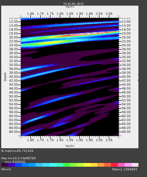
| Estimated Moho Depth: |
18.0 km |
| Estimated Crust Vp/Vs: |
1.93 |
| Assumed Crust Vp: |
5.906 km/s |
| Estimated Crust Vs: |
3.06 km/s |
| Estimated Crust Poisson's Ratio: |
0.32 |
|
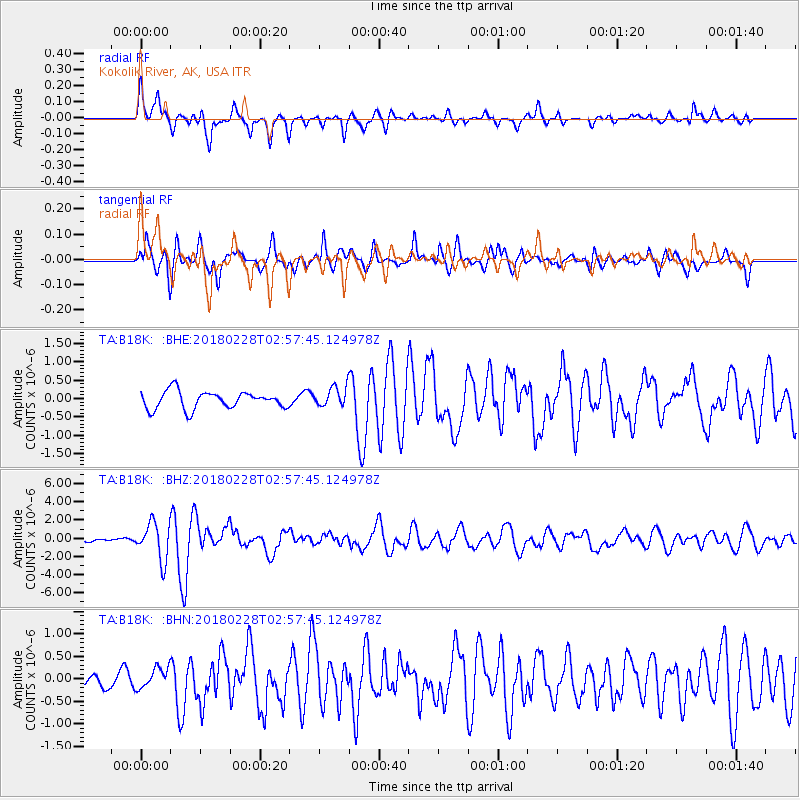
| Radial Match: |
85.741844 % |
| Radial Bump: |
400 |
| Transverse Match: |
82.403786 % |
| Transverse Bump: |
400 |
| SOD ConfigId: |
13570011 |
| Insert Time: |
2019-04-29 21:29:21.975 +0000 |
| GWidth: |
2.5 |
| Max Bumps: |
400 |
| Tol: |
0.001 |
|
Signal To Noise
| Channel | StoN | STA | LTA |
| TA:B18K: :BHZ:20180228T02:57:45.124978Z | 10.531183 | 2.0543666E-6 | 1.9507462E-7 |
| TA:B18K: :BHN:20180228T02:57:45.124978Z | 1.2447387 | 2.3385121E-7 | 1.8787173E-7 |
| TA:B18K: :BHE:20180228T02:57:45.124978Z | 1.1732416 | 2.7519258E-7 | 2.3455748E-7 |
| Arrivals |
| Ps | 2.9 SECOND |
| PpPs | 8.8 SECOND |
| PsPs/PpSs | 12 SECOND |


