You are here: Home > Network List > TA - USArray Transportable Network (new EarthScope stations) Stations List
> Station C16K Lisburne Hills, AK, USA > Earthquake Result Viewer
C16K Lisburne Hills, AK, USA - Earthquake Result Viewer
| Earthquake location: |
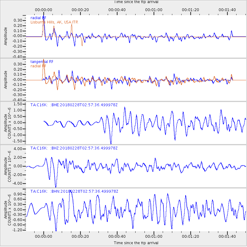
New Guinea, Papua New Guinea |
| Earthquake latitude/longitude: |
-6.2/142.5 |
| Earthquake time(UTC): |
2018/02/28 (059) 02:45:44 GMT |
| Earthquake Depth: |
10 km |
| Earthquake Magnitude: |
6.0 Mww |
| Earthquake Catalog/Contributor: |
NEIC PDE/us |
|
| Network: |
TA USArray Transportable Network (new EarthScope stations) |
| Station: |
C16K Lisburne Hills, AK, USA |
| Lat/Lon: |
68.27 N/165.34 W |
| Elevation: |
102 m |
|
| Distance: |
82.7 deg |
| Az: |
17.25 deg |
| Baz: |
232.367 deg |
| Ray Param: |
0.04673737 |
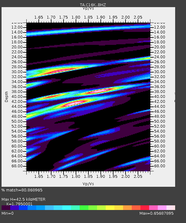
| Estimated Moho Depth: |
42.5 km |
| Estimated Crust Vp/Vs: |
1.80 |
| Assumed Crust Vp: |
5.906 km/s |
| Estimated Crust Vs: |
3.291 km/s |
| Estimated Crust Poisson's Ratio: |
0.27 |
|
| Radial Match: |
80.868965 % |
| Radial Bump: |
400 |
| Transverse Match: |
77.73767 % |
| Transverse Bump: |
322 |
| SOD ConfigId: |
13570011 |
| Insert Time: |
2019-04-29 21:29:22.468 +0000 |
| GWidth: |
2.5 |
| Max Bumps: |
400 |
| Tol: |
0.001 |
|
Signal To Noise
| Channel | StoN | STA | LTA |
| TA:C16K: :BHZ:20180228T02:57:36.499978Z | 6.447953 | 1.4940042E-6 | 2.317021E-7 |
| TA:C16K: :BHN:20180228T02:57:36.499978Z | 1.3700037 | 3.152389E-7 | 2.3010077E-7 |
| TA:C16K: :BHE:20180228T02:57:36.499978Z | 2.5735066 | 3.9185483E-7 | 1.5226493E-7 |
| Arrivals |
| Ps | 5.8 SECOND |
| PpPs | 20 SECOND |
| PsPs/PpSs | 26 SECOND |


