You are here: Home > Network List > NM - Cooperative New Madrid Seismic Network Stations List
> Station PEBM Pemiscot Bayou,MO > Earthquake Result Viewer
PEBM Pemiscot Bayou,MO - Earthquake Result Viewer
| Earthquake location: |
Near Coast Of Ecuador |
| Earthquake latitude/longitude: |
0.6/-80.3 |
| Earthquake time(UTC): |
2016/04/23 (114) 01:24:34 GMT |
| Earthquake Depth: |
10 km |
| Earthquake Magnitude: |
5.8 MWP |
| Earthquake Catalog/Contributor: |
NEIC PDE/NEIC COMCAT |
|
| Network: |
NM Cooperative New Madrid Seismic Network |
| Station: |
PEBM Pemiscot Bayou,MO |
| Lat/Lon: |
36.11 N/89.86 W |
| Elevation: |
76 m |
|
| Distance: |
36.4 deg |
| Az: |
346.87 deg |
| Baz: |
163.708 deg |
| Ray Param: |
0.07667969 |
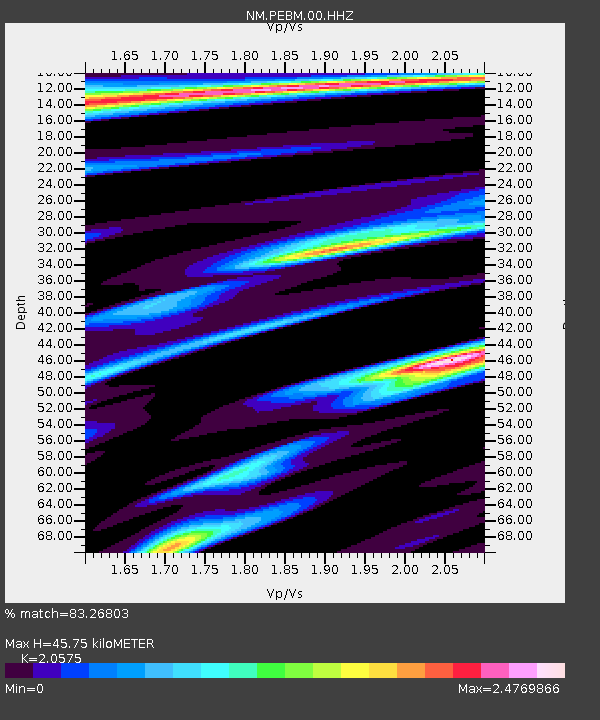
| Estimated Moho Depth: |
45.75 km |
| Estimated Crust Vp/Vs: |
2.06 |
| Assumed Crust Vp: |
6.444 km/s |
| Estimated Crust Vs: |
3.132 km/s |
| Estimated Crust Poisson's Ratio: |
0.35 |
|
| Radial Match: |
83.26803 % |
| Radial Bump: |
369 |
| Transverse Match: |
56.12321 % |
| Transverse Bump: |
400 |
| SOD ConfigId: |
1475611 |
| Insert Time: |
2016-05-07 01:31:01.527 +0000 |
| GWidth: |
2.5 |
| Max Bumps: |
400 |
| Tol: |
0.001 |
|

Signal To Noise
| Channel | StoN | STA | LTA |
| NM:PEBM:00:HHZ:20160423T01:31:08.01001Z | 4.156842 | 9.862789E-7 | 2.3726639E-7 |
| NM:PEBM:00:HHN:20160423T01:31:08.01001Z | 2.3952386 | 1.1234481E-6 | 4.6903392E-7 |
| NM:PEBM:00:HHE:20160423T01:31:08.01001Z | 1.5732616 | 5.8402475E-7 | 3.7121907E-7 |
| Arrivals |
| Ps | 8.0 SECOND |
| PpPs | 20 SECOND |
| PsPs/PpSs | 28 SECOND |


