You are here: Home > Network List > TA - USArray Transportable Network (new EarthScope stations) Stations List
> Station E19K Redstone River, AK, USA > Earthquake Result Viewer
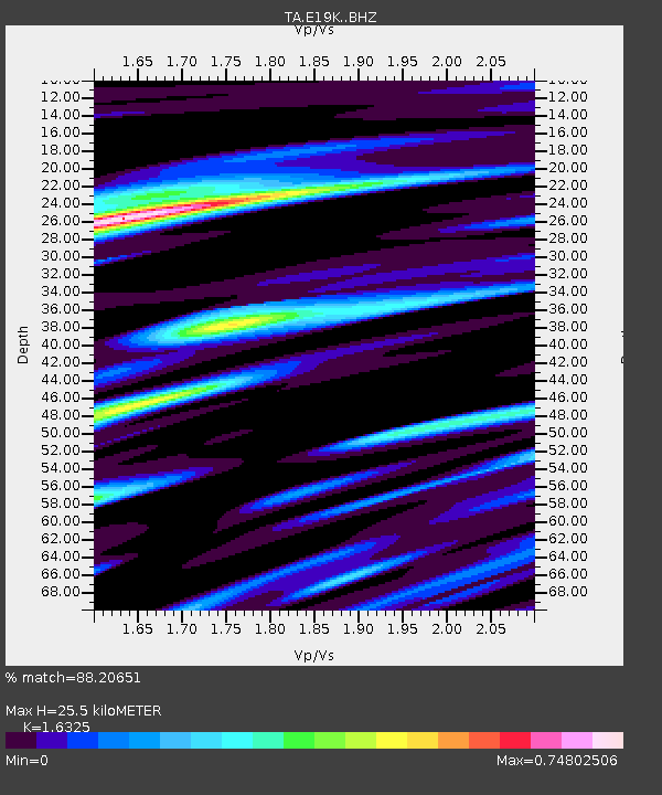
E19K Redstone River, AK, USA - Earthquake Result Viewer
| Earthquake location: |
New Guinea, Papua New Guinea |
| Earthquake latitude/longitude: |
-6.2/142.5 |
| Earthquake time(UTC): |
2018/02/28 (059) 02:45:44 GMT |
| Earthquake Depth: |
10 km |
| Earthquake Magnitude: |
6.0 Mww |
| Earthquake Catalog/Contributor: |
NEIC PDE/us |
|
| Network: |
TA USArray Transportable Network (new EarthScope stations) |
| Station: |
E19K Redstone River, AK, USA |
| Lat/Lon: |
67.46 N/157.23 W |
| Elevation: |
441 m |
|
| Distance: |
84.8 deg |
| Az: |
19.652 deg |
| Baz: |
240.14 deg |
| Ray Param: |
0.045256477 |
| Estimated Moho Depth: |
25.5 km |
| Estimated Crust Vp/Vs: |
1.63 |
| Assumed Crust Vp: |
6.577 km/s |
| Estimated Crust Vs: |
4.029 km/s |
| Estimated Crust Poisson's Ratio: |
0.20 |
|
| Radial Match: |
88.20651 % |
| Radial Bump: |
400 |
| Transverse Match: |
80.755135 % |
| Transverse Bump: |
400 |
| SOD ConfigId: |
13570011 |
| Insert Time: |
2019-04-29 21:29:35.642 +0000 |
| GWidth: |
2.5 |
| Max Bumps: |
400 |
| Tol: |
0.001 |
|

Signal To Noise
| Channel | StoN | STA | LTA |
| TA:E19K: :BHZ:20180228T02:57:47.225015Z | 13.216775 | 1.7649071E-6 | 1.335354E-7 |
| TA:E19K: :BHN:20180228T02:57:47.225015Z | 1.7275754 | 2.837885E-7 | 1.6426982E-7 |
| TA:E19K: :BHE:20180228T02:57:47.225015Z | 4.736426 | 5.7914264E-7 | 1.222742E-7 |
| Arrivals |
| Ps | 2.5 SECOND |
| PpPs | 9.9 SECOND |
| PsPs/PpSs | 12 SECOND |


