You are here: Home > Network List > TA - USArray Transportable Network (new EarthScope stations) Stations List
> Station F18K Selawik, AK, USA > Earthquake Result Viewer
F18K Selawik, AK, USA - Earthquake Result Viewer
| Earthquake location: |
New Guinea, Papua New Guinea |
| Earthquake latitude/longitude: |
-6.2/142.5 |
| Earthquake time(UTC): |
2018/02/28 (059) 02:45:44 GMT |
| Earthquake Depth: |
10 km |
| Earthquake Magnitude: |
6.0 Mww |
| Earthquake Catalog/Contributor: |
NEIC PDE/us |
|
| Network: |
TA USArray Transportable Network (new EarthScope stations) |
| Station: |
F18K Selawik, AK, USA |
| Lat/Lon: |
66.60 N/159.65 W |
| Elevation: |
27 m |
|
| Distance: |
83.5 deg |
| Az: |
19.903 deg |
| Baz: |
237.94 deg |
| Ray Param: |
0.046147034 |
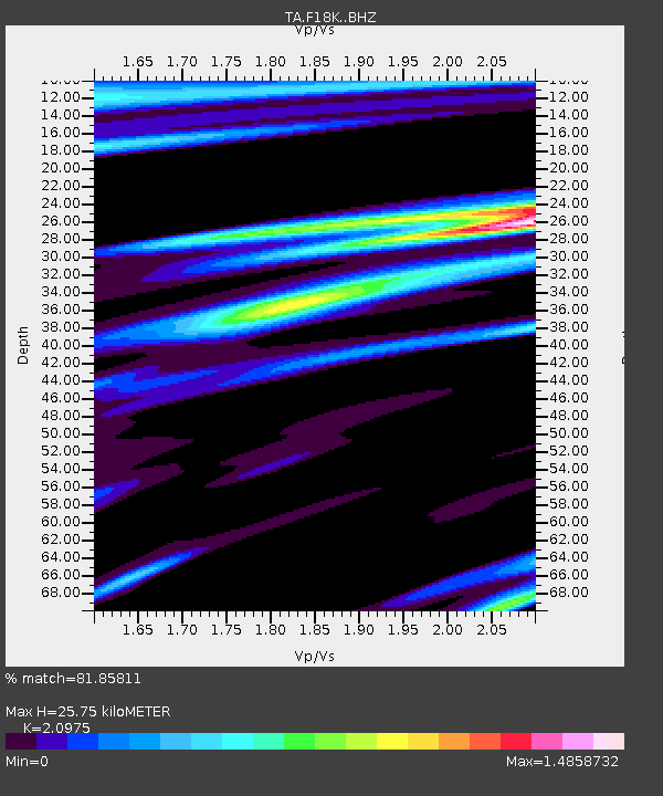
| Estimated Moho Depth: |
25.75 km |
| Estimated Crust Vp/Vs: |
2.10 |
| Assumed Crust Vp: |
6.577 km/s |
| Estimated Crust Vs: |
3.136 km/s |
| Estimated Crust Poisson's Ratio: |
0.35 |
|
| Radial Match: |
81.85811 % |
| Radial Bump: |
376 |
| Transverse Match: |
64.039566 % |
| Transverse Bump: |
400 |
| SOD ConfigId: |
13570011 |
| Insert Time: |
2019-04-29 21:29:41.275 +0000 |
| GWidth: |
2.5 |
| Max Bumps: |
400 |
| Tol: |
0.001 |
|

Signal To Noise
| Channel | StoN | STA | LTA |
| TA:F18K: :BHZ:20180228T02:57:40.850015Z | 5.932189 | 1.5082926E-6 | 2.5425564E-7 |
| TA:F18K: :BHN:20180228T02:57:40.850015Z | 1.9469175 | 6.0789984E-7 | 3.1223706E-7 |
| TA:F18K: :BHE:20180228T02:57:40.850015Z | 1.5430545 | 6.1022985E-7 | 3.9546876E-7 |
| Arrivals |
| Ps | 4.4 SECOND |
| PpPs | 12 SECOND |
| PsPs/PpSs | 16 SECOND |


