You are here: Home > Network List > TA - USArray Transportable Network (new EarthScope stations) Stations List
> Station H21K Melozitna River, AK, USA > Earthquake Result Viewer
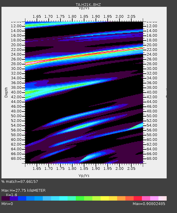
H21K Melozitna River, AK, USA - Earthquake Result Viewer
| Earthquake location: |
New Guinea, Papua New Guinea |
| Earthquake latitude/longitude: |
-6.2/142.5 |
| Earthquake time(UTC): |
2018/02/28 (059) 02:45:44 GMT |
| Earthquake Depth: |
10 km |
| Earthquake Magnitude: |
6.0 Mww |
| Earthquake Catalog/Contributor: |
NEIC PDE/us |
|
| Network: |
TA USArray Transportable Network (new EarthScope stations) |
| Station: |
H21K Melozitna River, AK, USA |
| Lat/Lon: |
65.66 N/152.80 W |
| Elevation: |
520 m |
|
| Distance: |
85.5 deg |
| Az: |
22.084 deg |
| Baz: |
244.404 deg |
| Ray Param: |
0.044734146 |
| Estimated Moho Depth: |
27.75 km |
| Estimated Crust Vp/Vs: |
1.60 |
| Assumed Crust Vp: |
6.566 km/s |
| Estimated Crust Vs: |
4.104 km/s |
| Estimated Crust Poisson's Ratio: |
0.18 |
|
| Radial Match: |
87.66157 % |
| Radial Bump: |
391 |
| Transverse Match: |
77.52119 % |
| Transverse Bump: |
400 |
| SOD ConfigId: |
13570011 |
| Insert Time: |
2019-04-29 21:30:02.427 +0000 |
| GWidth: |
2.5 |
| Max Bumps: |
400 |
| Tol: |
0.001 |
|

Signal To Noise
| Channel | StoN | STA | LTA |
| TA:H21K: :BHZ:20180228T02:57:50.850015Z | 7.3060513 | 1.2852972E-6 | 1.7592228E-7 |
| TA:H21K: :BHN:20180228T02:57:50.850015Z | 1.2737287 | 1.9094554E-7 | 1.4991068E-7 |
| TA:H21K: :BHE:20180228T02:57:50.850015Z | 2.6307845 | 5.534674E-7 | 2.1038113E-7 |
| Arrivals |
| Ps | 2.6 SECOND |
| PpPs | 11 SECOND |
| PsPs/PpSs | 13 SECOND |


