You are here: Home > Network List > TA - USArray Transportable Network (new EarthScope stations) Stations List
> Station H22K Ishtalitna Creek, AK, USA > Earthquake Result Viewer
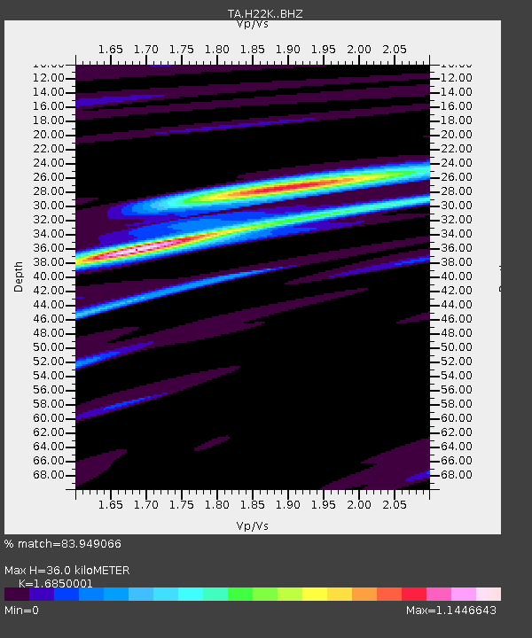
H22K Ishtalitna Creek, AK, USA - Earthquake Result Viewer
| Earthquake location: |
New Guinea, Papua New Guinea |
| Earthquake latitude/longitude: |
-6.2/142.5 |
| Earthquake time(UTC): |
2018/02/28 (059) 02:45:44 GMT |
| Earthquake Depth: |
10 km |
| Earthquake Magnitude: |
6.0 Mww |
| Earthquake Catalog/Contributor: |
NEIC PDE/us |
|
| Network: |
TA USArray Transportable Network (new EarthScope stations) |
| Station: |
H22K Ishtalitna Creek, AK, USA |
| Lat/Lon: |
65.89 N/151.38 W |
| Elevation: |
561 m |
|
| Distance: |
86.1 deg |
| Az: |
22.117 deg |
| Baz: |
245.707 deg |
| Ray Param: |
0.04428163 |
| Estimated Moho Depth: |
36.0 km |
| Estimated Crust Vp/Vs: |
1.69 |
| Assumed Crust Vp: |
6.566 km/s |
| Estimated Crust Vs: |
3.897 km/s |
| Estimated Crust Poisson's Ratio: |
0.23 |
|
| Radial Match: |
83.949066 % |
| Radial Bump: |
400 |
| Transverse Match: |
75.179436 % |
| Transverse Bump: |
400 |
| SOD ConfigId: |
13570011 |
| Insert Time: |
2019-04-29 21:30:03.144 +0000 |
| GWidth: |
2.5 |
| Max Bumps: |
400 |
| Tol: |
0.001 |
|

Signal To Noise
| Channel | StoN | STA | LTA |
| TA:H22K: :BHZ:20180228T02:57:53.975015Z | 8.615969 | 1.362568E-6 | 1.581445E-7 |
| TA:H22K: :BHN:20180228T02:57:53.975015Z | 0.996703 | 2.054026E-7 | 2.0608205E-7 |
| TA:H22K: :BHE:20180228T02:57:53.975015Z | 3.0708613 | 4.55357E-7 | 1.4828315E-7 |
| Arrivals |
| Ps | 3.9 SECOND |
| PpPs | 14 SECOND |
| PsPs/PpSs | 18 SECOND |


