You are here: Home > Network List > TA - USArray Transportable Network (new EarthScope stations) Stations List
> Station H16A Russell Place, West Yellowstone, MT, USA > Earthquake Result Viewer
H16A Russell Place, West Yellowstone, MT, USA - Earthquake Result Viewer
| Earthquake location: |
Santiago Del Estero Prov., Arg. |
| Earthquake latitude/longitude: |
-26.7/-63.2 |
| Earthquake time(UTC): |
2008/09/03 (247) 11:25:14 GMT |
| Earthquake Depth: |
570 km |
| Earthquake Magnitude: |
5.9 MB, 6.3 MW, 6.3 MW |
| Earthquake Catalog/Contributor: |
WHDF/NEIC |
|
| Network: |
TA USArray Transportable Network (new EarthScope stations) |
| Station: |
H16A Russell Place, West Yellowstone, MT, USA |
| Lat/Lon: |
44.70 N/111.25 W |
| Elevation: |
2080 m |
|
| Distance: |
83.5 deg |
| Az: |
327.755 deg |
| Baz: |
138.002 deg |
| Ray Param: |
0.04445245 |
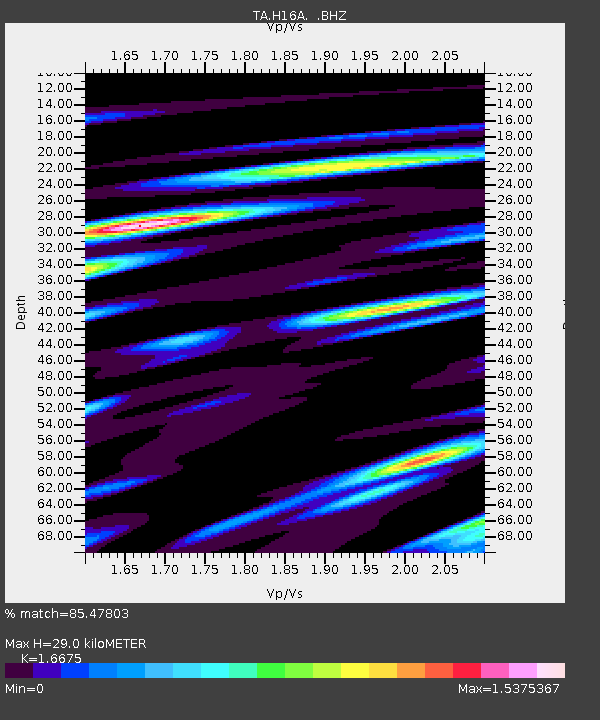
| Estimated Moho Depth: |
29.0 km |
| Estimated Crust Vp/Vs: |
1.67 |
| Assumed Crust Vp: |
6.35 km/s |
| Estimated Crust Vs: |
3.808 km/s |
| Estimated Crust Poisson's Ratio: |
0.22 |
|
| Radial Match: |
85.47803 % |
| Radial Bump: |
379 |
| Transverse Match: |
76.05577 % |
| Transverse Bump: |
400 |
| SOD ConfigId: |
2504 |
| Insert Time: |
2010-03-06 09:28:54.674 +0000 |
| GWidth: |
2.5 |
| Max Bumps: |
400 |
| Tol: |
0.001 |
|

Signal To Noise
| Channel | StoN | STA | LTA |
| TA:H16A: :BHZ:20080903T11:36:11.825Z | 10.146769 | 8.943153E-7 | 8.8137945E-8 |
| TA:H16A: :BHN:20080903T11:36:11.825Z | 5.6255903 | 3.521934E-7 | 6.260559E-8 |
| TA:H16A: :BHE:20080903T11:36:11.825Z | 4.9034457 | 2.8880456E-7 | 5.8898287E-8 |
| Arrivals |
| Ps | 3.1 SECOND |
| PpPs | 12 SECOND |
| PsPs/PpSs | 15 SECOND |


