You are here: Home > Network List > TA - USArray Transportable Network (new EarthScope stations) Stations List
> Station H16A Russell Place, West Yellowstone, MT, USA > Earthquake Result Viewer
H16A Russell Place, West Yellowstone, MT, USA - Earthquake Result Viewer

| Earthquake location: |
Vanuatu Islands |
| Earthquake latitude/longitude: |
-14.8/168.0 |
| Earthquake time(UTC): |
2008/11/07 (312) 07:19:35 GMT |
| Earthquake Depth: |
13 km |
| Earthquake Magnitude: |
6.0 MB, 6.3 MS, 6.4 MW, 6.4 MW |
| Earthquake Catalog/Contributor: |
WHDF/NEIC |
|
| Network: |
TA USArray Transportable Network (new EarthScope stations) |
| Station: |
H16A Russell Place, West Yellowstone, MT, USA |
| Lat/Lon: |
44.70 N/111.25 W |
| Elevation: |
2080 m |
|
| Distance: |
93.8 deg |
| Az: |
44.859 deg |
| Baz: |
253.061 deg |
| Ray Param: |
0.041178238 |
| Estimated Moho Depth: |
26.25 km |
| Estimated Crust Vp/Vs: |
1.60 |
| Assumed Crust Vp: |
6.35 km/s |
| Estimated Crust Vs: |
3.969 km/s |
| Estimated Crust Poisson's Ratio: |
0.18 |
|
| Radial Match: |
83.552864 % |
| Radial Bump: |
316 |
| Transverse Match: |
62.1964 % |
| Transverse Bump: |
400 |
| SOD ConfigId: |
2658 |
| Insert Time: |
2010-03-06 09:28:55.906 +0000 |
| GWidth: |
2.5 |
| Max Bumps: |
400 |
| Tol: |
0.001 |
|
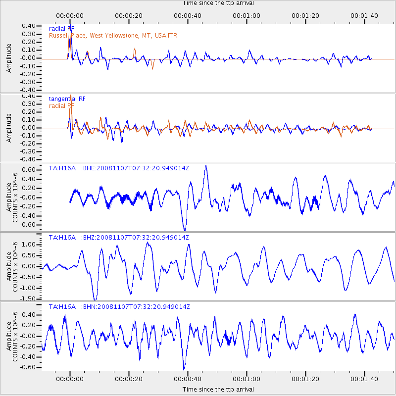
Signal To Noise
| Channel | StoN | STA | LTA |
| TA:H16A: :BHZ:20081107T07:32:20.949014Z | 2.6641848 | 3.4014204E-7 | 1.276721E-7 |
| TA:H16A: :BHN:20081107T07:32:20.949014Z | 1.3447154 | 2.0615995E-7 | 1.5331122E-7 |
| TA:H16A: :BHE:20081107T07:32:20.949014Z | 1.3269459 | 1.3113876E-7 | 9.882752E-8 |
| Arrivals |
| Ps | 2.5 SECOND |
| PpPs | 11 SECOND |
| PsPs/PpSs | 13 SECOND |


