You are here: Home > Network List > TA - USArray Transportable Network (new EarthScope stations) Stations List
> Station L15K Ungalak Mountain, AK, USA > Earthquake Result Viewer
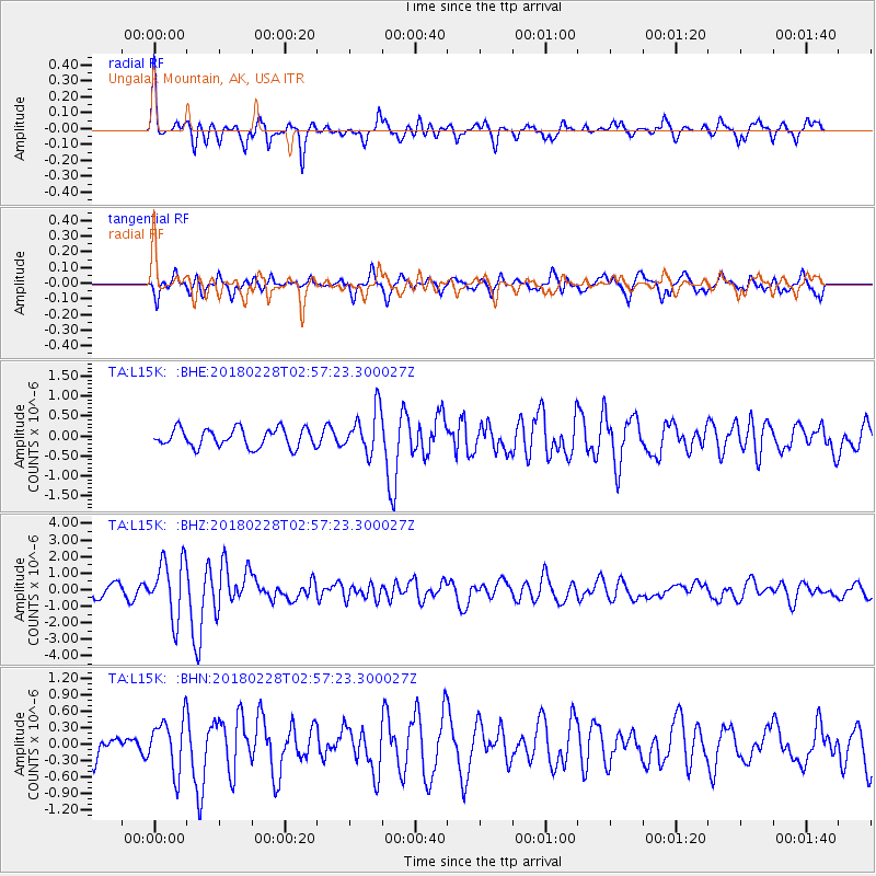
L15K Ungalak Mountain, AK, USA - Earthquake Result Viewer
*The percent match for this event was below the threshold and hence no stack was calculated.
| Earthquake location: |
New Guinea, Papua New Guinea |
| Earthquake latitude/longitude: |
-6.2/142.5 |
| Earthquake time(UTC): |
2018/02/28 (059) 02:45:44 GMT |
| Earthquake Depth: |
10 km |
| Earthquake Magnitude: |
6.0 Mww |
| Earthquake Catalog/Contributor: |
NEIC PDE/us |
|
| Network: |
TA USArray Transportable Network (new EarthScope stations) |
| Station: |
L15K Ungalak Mountain, AK, USA |
| Lat/Lon: |
61.68 N/161.49 W |
| Elevation: |
219 m |
|
| Distance: |
80.2 deg |
| Az: |
23.669 deg |
| Baz: |
236.824 deg |
| Ray Param: |
$rayparam |
*The percent match for this event was below the threshold and hence was not used in the summary stack. |
|
| Radial Match: |
74.44507 % |
| Radial Bump: |
400 |
| Transverse Match: |
71.19834 % |
| Transverse Bump: |
400 |
| SOD ConfigId: |
13570011 |
| Insert Time: |
2019-04-29 21:30:25.312 +0000 |
| GWidth: |
2.5 |
| Max Bumps: |
400 |
| Tol: |
0.001 |
|
Signal To Noise
| Channel | StoN | STA | LTA |
| TA:L15K: :BHZ:20180228T02:57:23.300027Z | 6.428712 | 1.751423E-6 | 2.7243763E-7 |
| TA:L15K: :BHN:20180228T02:57:23.300027Z | 1.8420095 | 4.7902137E-7 | 2.6005367E-7 |
| TA:L15K: :BHE:20180228T02:57:23.300027Z | 2.3444679 | 5.4285346E-7 | 2.3154657E-7 |
| Arrivals |
| Ps | |
| PpPs | |
| PsPs/PpSs | |


