You are here: Home > Network List > TA - USArray Transportable Network (new EarthScope stations) Stations List
> Station H16A Russell Place, West Yellowstone, MT, USA > Earthquake Result Viewer
H16A Russell Place, West Yellowstone, MT, USA - Earthquake Result Viewer
| Earthquake location: |
Near Coast Of Chiapas, Mexico |
| Earthquake latitude/longitude: |
14.4/-92.4 |
| Earthquake time(UTC): |
2008/10/16 (290) 19:41:25 GMT |
| Earthquake Depth: |
24 km |
| Earthquake Magnitude: |
6.1 MB, 6.6 MS, 6.7 MW, 6.6 MW |
| Earthquake Catalog/Contributor: |
WHDF/NEIC |
|
| Network: |
TA USArray Transportable Network (new EarthScope stations) |
| Station: |
H16A Russell Place, West Yellowstone, MT, USA |
| Lat/Lon: |
44.70 N/111.25 W |
| Elevation: |
2080 m |
|
| Distance: |
34.2 deg |
| Az: |
335.745 deg |
| Baz: |
146.073 deg |
| Ray Param: |
0.07783399 |
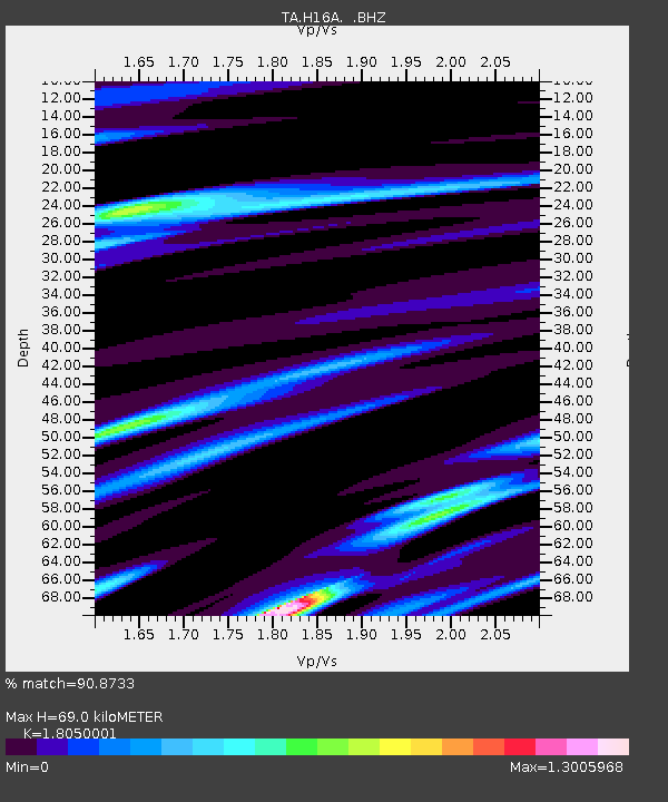
| Estimated Moho Depth: |
69.0 km |
| Estimated Crust Vp/Vs: |
1.81 |
| Assumed Crust Vp: |
6.35 km/s |
| Estimated Crust Vs: |
3.518 km/s |
| Estimated Crust Poisson's Ratio: |
0.28 |
|
| Radial Match: |
90.8733 % |
| Radial Bump: |
400 |
| Transverse Match: |
83.496414 % |
| Transverse Bump: |
400 |
| SOD ConfigId: |
2560 |
| Insert Time: |
2010-03-06 09:29:04.382 +0000 |
| GWidth: |
2.5 |
| Max Bumps: |
400 |
| Tol: |
0.001 |
|

Signal To Noise
| Channel | StoN | STA | LTA |
| TA:H16A: :BHZ:20081016T19:47:38.475005Z | 12.5244875 | 2.6312268E-6 | 2.1008658E-7 |
| TA:H16A: :BHN:20081016T19:47:38.475005Z | 9.8214655 | 1.4786733E-6 | 1.5055527E-7 |
| TA:H16A: :BHE:20081016T19:47:38.475005Z | 4.623405 | 9.1287006E-7 | 1.974454E-7 |
| Arrivals |
| Ps | 9.4 SECOND |
| PpPs | 28 SECOND |
| PsPs/PpSs | 38 SECOND |


