You are here: Home > Network List > TA - USArray Transportable Network (new EarthScope stations) Stations List
> Station M15K Kasigluk River, AK, USA > Earthquake Result Viewer
M15K Kasigluk River, AK, USA - Earthquake Result Viewer
| Earthquake location: |
New Guinea, Papua New Guinea |
| Earthquake latitude/longitude: |
-6.2/142.5 |
| Earthquake time(UTC): |
2018/02/28 (059) 02:45:44 GMT |
| Earthquake Depth: |
10 km |
| Earthquake Magnitude: |
6.0 Mww |
| Earthquake Catalog/Contributor: |
NEIC PDE/us |
|
| Network: |
TA USArray Transportable Network (new EarthScope stations) |
| Station: |
M15K Kasigluk River, AK, USA |
| Lat/Lon: |
60.69 N/160.69 W |
| Elevation: |
210 m |
|
| Distance: |
79.9 deg |
| Az: |
24.725 deg |
| Baz: |
237.705 deg |
| Ray Param: |
0.048613876 |
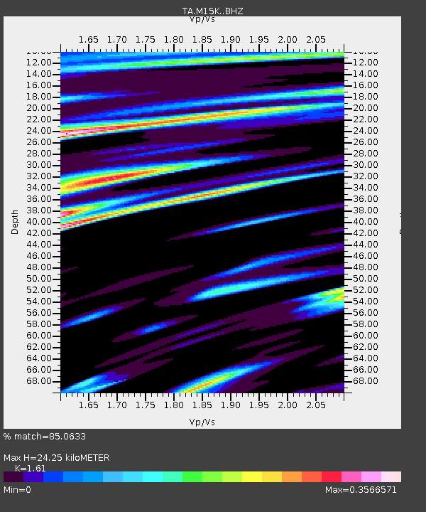
| Estimated Moho Depth: |
24.25 km |
| Estimated Crust Vp/Vs: |
1.61 |
| Assumed Crust Vp: |
6.182 km/s |
| Estimated Crust Vs: |
3.84 km/s |
| Estimated Crust Poisson's Ratio: |
0.19 |
|
| Radial Match: |
85.0633 % |
| Radial Bump: |
400 |
| Transverse Match: |
73.84808 % |
| Transverse Bump: |
400 |
| SOD ConfigId: |
13570011 |
| Insert Time: |
2019-04-29 21:30:33.563 +0000 |
| GWidth: |
2.5 |
| Max Bumps: |
400 |
| Tol: |
0.001 |
|

Signal To Noise
| Channel | StoN | STA | LTA |
| TA:M15K: :BHZ:20180228T02:57:22.175027Z | 10.900524 | 2.5742427E-6 | 2.361577E-7 |
| TA:M15K: :BHN:20180228T02:57:22.175027Z | 1.8465962 | 5.473129E-7 | 2.9639014E-7 |
| TA:M15K: :BHE:20180228T02:57:22.175027Z | 2.5500236 | 8.106424E-7 | 3.1789605E-7 |
| Arrivals |
| Ps | 2.5 SECOND |
| PpPs | 9.9 SECOND |
| PsPs/PpSs | 12 SECOND |


