You are here: Home > Network List > TA - USArray Transportable Network (new EarthScope stations) Stations List
> Station I23K Minto, Yukon-Koyukuk, AK, USA > Earthquake Result Viewer
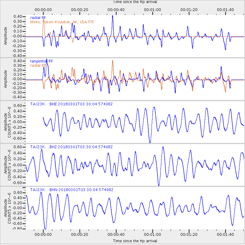
I23K Minto, Yukon-Koyukuk, AK, USA - Earthquake Result Viewer
*The percent match for this event was below the threshold and hence no stack was calculated.
| Earthquake location: |
Northern Sumatra, Indonesia |
| Earthquake latitude/longitude: |
1.0/98.7 |
| Earthquake time(UTC): |
2018/03/01 (060) 03:17:06 GMT |
| Earthquake Depth: |
71 km |
| Earthquake Magnitude: |
5.2 Mww |
| Earthquake Catalog/Contributor: |
NEIC PDE/us |
|
| Network: |
TA USArray Transportable Network (new EarthScope stations) |
| Station: |
I23K Minto, Yukon-Koyukuk, AK, USA |
| Lat/Lon: |
65.15 N/149.36 W |
| Elevation: |
149 m |
|
| Distance: |
98.2 deg |
| Az: |
23.334 deg |
| Baz: |
290.428 deg |
| Ray Param: |
$rayparam |
*The percent match for this event was below the threshold and hence was not used in the summary stack. |
|
| Radial Match: |
51.19178 % |
| Radial Bump: |
317 |
| Transverse Match: |
56.46292 % |
| Transverse Bump: |
382 |
| SOD ConfigId: |
13570011 |
| Insert Time: |
2019-04-29 21:34:29.788 +0000 |
| GWidth: |
2.5 |
| Max Bumps: |
400 |
| Tol: |
0.001 |
|
Signal To Noise
| Channel | StoN | STA | LTA |
| TA:I23K: :BHZ:20180301T03:30:04.57498Z | 1.2760096 | 2.6874184E-7 | 2.1061116E-7 |
| TA:I23K: :BHN:20180301T03:30:04.57498Z | 2.1338985 | 5.0091614E-7 | 2.3474226E-7 |
| TA:I23K: :BHE:20180301T03:30:04.57498Z | 0.43849757 | 9.3128776E-8 | 2.1238152E-7 |
| Arrivals |
| Ps | |
| PpPs | |
| PsPs/PpSs | |


