You are here: Home > Network List > TA - USArray Transportable Network (new EarthScope stations) Stations List
> Station H16A Russell Place, West Yellowstone, MT, USA > Earthquake Result Viewer
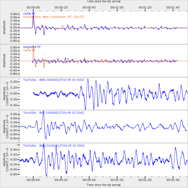
H16A Russell Place, West Yellowstone, MT, USA - Earthquake Result Viewer
| Earthquake location: |
Off Coast Of Costa Rica |
| Earthquake latitude/longitude: |
7.9/-85.6 |
| Earthquake time(UTC): |
2009/08/13 (225) 09:37:35 GMT |
| Earthquake Depth: |
10 km |
| Earthquake Magnitude: |
5.8 MW, 5.3 MB |
| Earthquake Catalog/Contributor: |
WHDF/NEIC |
|
| Network: |
TA USArray Transportable Network (new EarthScope stations) |
| Station: |
H16A Russell Place, West Yellowstone, MT, USA |
| Lat/Lon: |
44.70 N/111.25 W |
| Elevation: |
2080 m |
|
| Distance: |
42.8 deg |
| Az: |
333.039 deg |
| Baz: |
140.968 deg |
| Ray Param: |
0.07293146 |
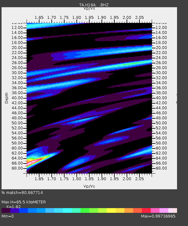
| Estimated Moho Depth: |
65.5 km |
| Estimated Crust Vp/Vs: |
1.62 |
| Assumed Crust Vp: |
6.35 km/s |
| Estimated Crust Vs: |
3.92 km/s |
| Estimated Crust Poisson's Ratio: |
0.19 |
|
| Radial Match: |
90.867714 % |
| Radial Bump: |
263 |
| Transverse Match: |
73.06236 % |
| Transverse Bump: |
373 |
| SOD ConfigId: |
2622 |
| Insert Time: |
2010-03-06 09:29:34.663 +0000 |
| GWidth: |
2.5 |
| Max Bumps: |
400 |
| Tol: |
0.001 |
|
Signal To Noise
| Channel | StoN | STA | LTA |
| TA:H16A: :BHZ:20090813T09:45:02.600Z | 3.0973327 | 2.3569369E-7 | 7.6095695E-8 |
| TA:H16A: :BHN:20090813T09:45:02.600Z | 4.5638347 | 1.4637237E-7 | 3.2072233E-8 |
| TA:H16A: :BHE:20090813T09:45:02.600Z | 2.3576305 | 1.0983037E-7 | 4.6585065E-8 |
| Arrivals |
| Ps | 6.9 SECOND |
| PpPs | 25 SECOND |
| PsPs/PpSs | 32 SECOND |


