You are here: Home > Network List > TM - Thai Seismic Monitoring Network Stations List
> Station NAYO NAYO staion > Earthquake Result Viewer
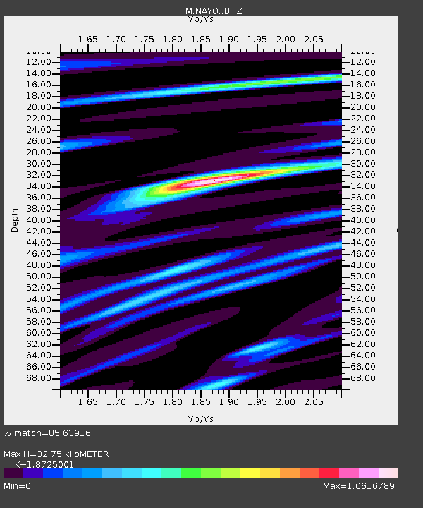
NAYO NAYO staion - Earthquake Result Viewer
| Earthquake location: |
Banda Sea |
| Earthquake latitude/longitude: |
-6.2/130.3 |
| Earthquake time(UTC): |
2018/03/02 (061) 02:20:12 GMT |
| Earthquake Depth: |
137 km |
| Earthquake Magnitude: |
5.9 Mww |
| Earthquake Catalog/Contributor: |
NEIC PDE/us |
|
| Network: |
TM Thai Seismic Monitoring Network |
| Station: |
NAYO NAYO staion |
| Lat/Lon: |
14.32 N/101.32 E |
| Elevation: |
106 m |
|
| Distance: |
35.2 deg |
| Az: |
305.49 deg |
| Baz: |
123.369 deg |
| Ray Param: |
0.076858014 |
| Estimated Moho Depth: |
32.75 km |
| Estimated Crust Vp/Vs: |
1.87 |
| Assumed Crust Vp: |
6.498 km/s |
| Estimated Crust Vs: |
3.47 km/s |
| Estimated Crust Poisson's Ratio: |
0.30 |
|
| Radial Match: |
85.63916 % |
| Radial Bump: |
331 |
| Transverse Match: |
52.682625 % |
| Transverse Bump: |
395 |
| SOD ConfigId: |
13570011 |
| Insert Time: |
2019-04-29 21:37:45.882 +0000 |
| GWidth: |
2.5 |
| Max Bumps: |
400 |
| Tol: |
0.001 |
|

Signal To Noise
| Channel | StoN | STA | LTA |
| TM:NAYO: :BHZ:20180302T02:26:22.999987Z | 5.068952 | 1.6242193E-5 | 3.2042506E-6 |
| TM:NAYO: :BHN:20180302T02:26:22.999987Z | 3.595905 | 5.2999644E-6 | 1.4738888E-6 |
| TM:NAYO: :BHE:20180302T02:26:22.999987Z | 5.615655 | 7.640992E-6 | 1.3606592E-6 |
| Arrivals |
| Ps | 4.7 SECOND |
| PpPs | 13 SECOND |
| PsPs/PpSs | 18 SECOND |


