You are here: Home > Network List > TA - USArray Transportable Network (new EarthScope stations) Stations List
> Station H16A Russell Place, West Yellowstone, MT, USA > Earthquake Result Viewer
H16A Russell Place, West Yellowstone, MT, USA - Earthquake Result Viewer
| Earthquake location: |
Panama |
| Earthquake latitude/longitude: |
9.6/-79.0 |
| Earthquake time(UTC): |
2009/07/04 (185) 06:49:35 GMT |
| Earthquake Depth: |
38 km |
| Earthquake Magnitude: |
6.0 MB, 5.5 MS, 6.0 MW, 6.0 MW |
| Earthquake Catalog/Contributor: |
WHDF/NEIC |
|
| Network: |
TA USArray Transportable Network (new EarthScope stations) |
| Station: |
H16A Russell Place, West Yellowstone, MT, USA |
| Lat/Lon: |
44.70 N/111.25 W |
| Elevation: |
2080 m |
|
| Distance: |
44.7 deg |
| Az: |
327.227 deg |
| Baz: |
131.53 deg |
| Ray Param: |
0.071664035 |
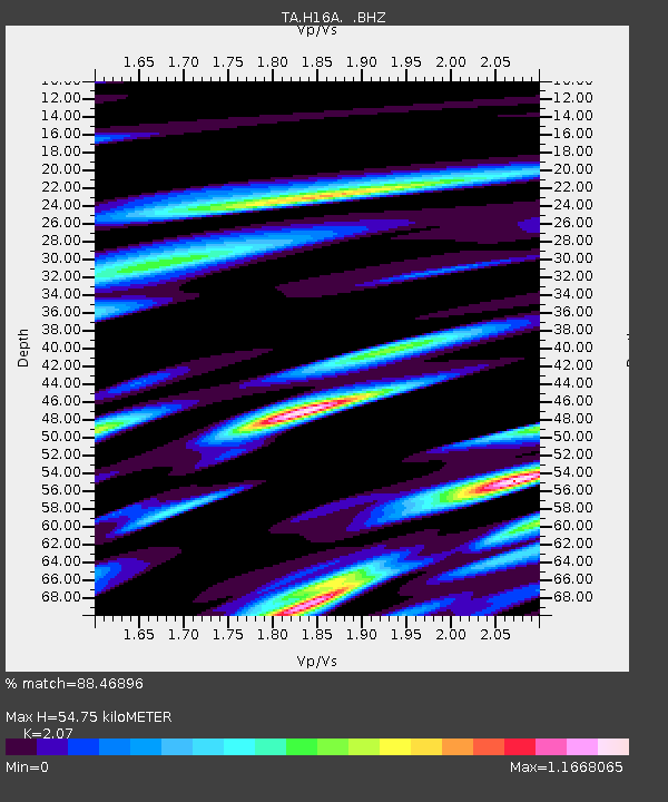
| Estimated Moho Depth: |
54.75 km |
| Estimated Crust Vp/Vs: |
2.07 |
| Assumed Crust Vp: |
6.35 km/s |
| Estimated Crust Vs: |
3.068 km/s |
| Estimated Crust Poisson's Ratio: |
0.35 |
|
| Radial Match: |
88.46896 % |
| Radial Bump: |
400 |
| Transverse Match: |
87.776924 % |
| Transverse Bump: |
400 |
| SOD ConfigId: |
2648 |
| Insert Time: |
2010-03-06 09:30:35.576 +0000 |
| GWidth: |
2.5 |
| Max Bumps: |
400 |
| Tol: |
0.001 |
|

Signal To Noise
| Channel | StoN | STA | LTA |
| TA:H16A: :BHZ:20090704T06:57:14.450002Z | 14.128857 | 6.916148E-7 | 4.8950515E-8 |
| TA:H16A: :BHN:20090704T06:57:14.450002Z | 6.613102 | 3.5715425E-7 | 5.4007067E-8 |
| TA:H16A: :BHE:20090704T06:57:14.450002Z | 8.922391 | 4.037468E-7 | 4.525097E-8 |
| Arrivals |
| Ps | 9.7 SECOND |
| PpPs | 25 SECOND |
| PsPs/PpSs | 35 SECOND |


