You are here: Home > Network List > TA - USArray Transportable Network (new EarthScope stations) Stations List
> Station H16A Russell Place, West Yellowstone, MT, USA > Earthquake Result Viewer
H16A Russell Place, West Yellowstone, MT, USA - Earthquake Result Viewer
| Earthquake location: |
Kuril Islands |
| Earthquake latitude/longitude: |
46.0/151.4 |
| Earthquake time(UTC): |
2009/04/18 (108) 19:17:58 GMT |
| Earthquake Depth: |
35 km |
| Earthquake Magnitude: |
6.3 MB, 6.3 MS, 6.6 MW, 6.4 MW |
| Earthquake Catalog/Contributor: |
WHDF/NEIC |
|
| Network: |
TA USArray Transportable Network (new EarthScope stations) |
| Station: |
H16A Russell Place, West Yellowstone, MT, USA |
| Lat/Lon: |
44.70 N/111.25 W |
| Elevation: |
2080 m |
|
| Distance: |
63.9 deg |
| Az: |
51.942 deg |
| Baz: |
309.694 deg |
| Ray Param: |
0.0591932 |
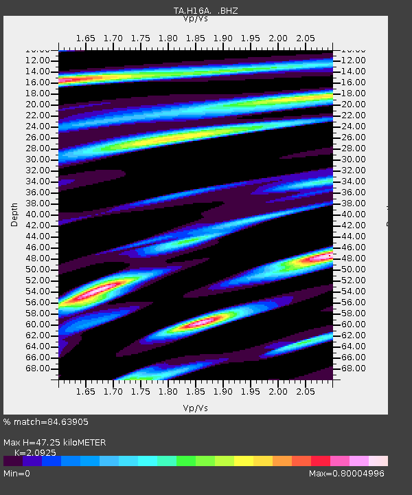
| Estimated Moho Depth: |
47.25 km |
| Estimated Crust Vp/Vs: |
2.09 |
| Assumed Crust Vp: |
6.35 km/s |
| Estimated Crust Vs: |
3.035 km/s |
| Estimated Crust Poisson's Ratio: |
0.35 |
|
| Radial Match: |
84.63905 % |
| Radial Bump: |
400 |
| Transverse Match: |
81.44633 % |
| Transverse Bump: |
400 |
| SOD ConfigId: |
2760 |
| Insert Time: |
2010-03-06 09:30:42.945 +0000 |
| GWidth: |
2.5 |
| Max Bumps: |
400 |
| Tol: |
0.001 |
|

Signal To Noise
| Channel | StoN | STA | LTA |
| TA:H16A: :BHZ:20090418T19:27:57.648994Z | 7.439443 | 1.2790686E-6 | 1.719307E-7 |
| TA:H16A: :BHN:20090418T19:27:57.648994Z | 1.7251849 | 3.3935115E-7 | 1.967042E-7 |
| TA:H16A: :BHE:20090418T19:27:57.648994Z | 2.7277184 | 5.0598004E-7 | 1.854957E-7 |
| Arrivals |
| Ps | 8.4 SECOND |
| PpPs | 22 SECOND |
| PsPs/PpSs | 31 SECOND |


