You are here: Home > Network List > US - United States National Seismic Network Stations List
> Station HAWA Hanford, Washington, USA > Earthquake Result Viewer
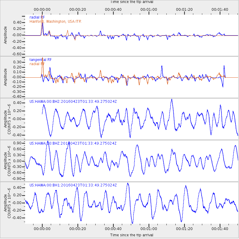
HAWA Hanford, Washington, USA - Earthquake Result Viewer
*The percent match for this event was below the threshold and hence no stack was calculated.
| Earthquake location: |
Near Coast Of Ecuador |
| Earthquake latitude/longitude: |
0.6/-80.3 |
| Earthquake time(UTC): |
2016/04/23 (114) 01:24:34 GMT |
| Earthquake Depth: |
10 km |
| Earthquake Magnitude: |
5.8 MWP |
| Earthquake Catalog/Contributor: |
NEIC PDE/NEIC COMCAT |
|
| Network: |
US United States National Seismic Network |
| Station: |
HAWA Hanford, Washington, USA |
| Lat/Lon: |
46.39 N/119.53 W |
| Elevation: |
364 m |
|
| Distance: |
57.1 deg |
| Az: |
328.547 deg |
| Baz: |
131.075 deg |
| Ray Param: |
$rayparam |
*The percent match for this event was below the threshold and hence was not used in the summary stack. |
|
| Radial Match: |
58.836285 % |
| Radial Bump: |
396 |
| Transverse Match: |
66.99351 % |
| Transverse Bump: |
400 |
| SOD ConfigId: |
1475611 |
| Insert Time: |
2016-05-07 01:33:10.737 +0000 |
| GWidth: |
2.5 |
| Max Bumps: |
400 |
| Tol: |
0.001 |
|
Signal To Noise
| Channel | StoN | STA | LTA |
| US:HAWA:00:BHZ:20160423T01:33:49.275024Z | 2.6129346 | 5.9275834E-7 | 2.268554E-7 |
| US:HAWA:00:BH1:20160423T01:33:49.275024Z | 1.5127828 | 1.9675191E-7 | 1.3005959E-7 |
| US:HAWA:00:BH2:20160423T01:33:49.275024Z | 1.4962074 | 2.7637319E-7 | 1.8471583E-7 |
| Arrivals |
| Ps | |
| PpPs | |
| PsPs/PpSs | |


