You are here: Home > Network List > TA - USArray Transportable Network (new EarthScope stations) Stations List
> Station H16A Russell Place, West Yellowstone, MT, USA > Earthquake Result Viewer
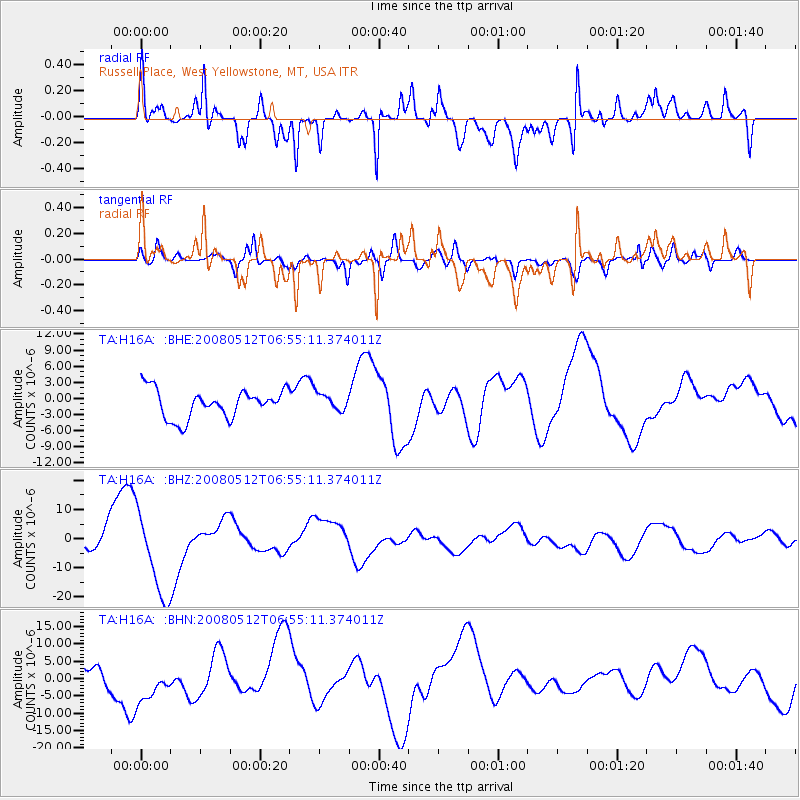
H16A Russell Place, West Yellowstone, MT, USA - Earthquake Result Viewer
*The percent match for this event was below the threshold and hence no stack was calculated.
| Earthquake location: |
Sichuan, China |
| Earthquake latitude/longitude: |
31.3/104.7 |
| Earthquake time(UTC): |
2008/05/12 (133) 06:42:08 GMT |
| Earthquake Depth: |
10 km |
| Earthquake Magnitude: |
5.7 MB |
| Earthquake Catalog/Contributor: |
WHDF/NEIC |
|
| Network: |
TA USArray Transportable Network (new EarthScope stations) |
| Station: |
H16A Russell Place, West Yellowstone, MT, USA |
| Lat/Lon: |
44.70 N/111.25 W |
| Elevation: |
2080 m |
|
| Distance: |
97.5 deg |
| Az: |
24.967 deg |
| Baz: |
329.572 deg |
| Ray Param: |
$rayparam |
*The percent match for this event was below the threshold and hence was not used in the summary stack. |
|
| Radial Match: |
78.973175 % |
| Radial Bump: |
400 |
| Transverse Match: |
66.23785 % |
| Transverse Bump: |
400 |
| SOD ConfigId: |
2504 |
| Insert Time: |
2010-03-06 09:31:37.329 +0000 |
| GWidth: |
2.5 |
| Max Bumps: |
400 |
| Tol: |
0.001 |
|
Signal To Noise
| Channel | StoN | STA | LTA |
| TA:H16A: :BHZ:20080512T06:55:11.374011Z | 2.800287 | 1.4466464E-5 | 5.166065E-6 |
| TA:H16A: :BHN:20080512T06:55:11.374011Z | 1.1502842 | 6.6737725E-6 | 5.801847E-6 |
| TA:H16A: :BHE:20080512T06:55:11.374011Z | 0.59644777 | 1.5848997E-6 | 2.6572313E-6 |
| Arrivals |
| Ps | |
| PpPs | |
| PsPs/PpSs | |


