You are here: Home > Network List > TA - USArray Transportable Network (new EarthScope stations) Stations List
> Station H16A Russell Place, West Yellowstone, MT, USA > Earthquake Result Viewer
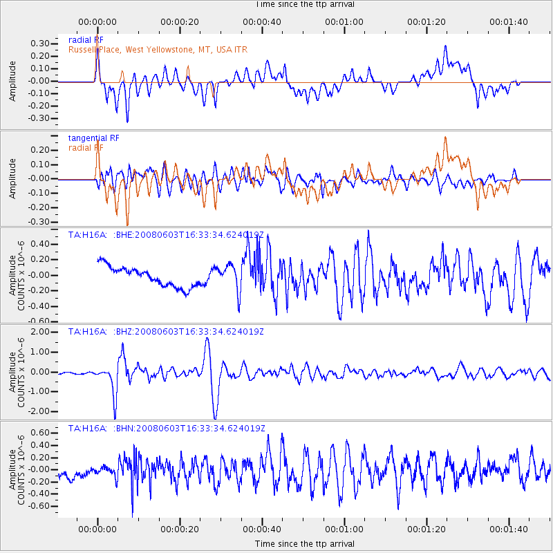
H16A Russell Place, West Yellowstone, MT, USA - Earthquake Result Viewer
*The percent match for this event was below the threshold and hence no stack was calculated.
| Earthquake location: |
Solomon Islands |
| Earthquake latitude/longitude: |
-10.5/161.3 |
| Earthquake time(UTC): |
2008/06/03 (155) 16:20:50 GMT |
| Earthquake Depth: |
84 km |
| Earthquake Magnitude: |
6.2 MB, 6.2 MW, 6.2 MW |
| Earthquake Catalog/Contributor: |
WHDF/NEIC |
|
| Network: |
TA USArray Transportable Network (new EarthScope stations) |
| Station: |
H16A Russell Place, West Yellowstone, MT, USA |
| Lat/Lon: |
44.70 N/111.25 W |
| Elevation: |
2080 m |
|
| Distance: |
95.5 deg |
| Az: |
45.704 deg |
| Baz: |
260.776 deg |
| Ray Param: |
$rayparam |
*The percent match for this event was below the threshold and hence was not used in the summary stack. |
|
| Radial Match: |
74.01828 % |
| Radial Bump: |
400 |
| Transverse Match: |
86.86186 % |
| Transverse Bump: |
400 |
| SOD ConfigId: |
2504 |
| Insert Time: |
2010-03-06 09:31:49.036 +0000 |
| GWidth: |
2.5 |
| Max Bumps: |
400 |
| Tol: |
0.001 |
|
Signal To Noise
| Channel | StoN | STA | LTA |
| TA:H16A: :BHZ:20080603T16:33:34.624019Z | 12.058379 | 7.5652935E-7 | 6.273889E-8 |
| TA:H16A: :BHN:20080603T16:33:34.624019Z | 0.9953575 | 8.7169596E-8 | 8.757617E-8 |
| TA:H16A: :BHE:20080603T16:33:34.624019Z | 1.3527435 | 1.7107651E-7 | 1.2646633E-7 |
| Arrivals |
| Ps | |
| PpPs | |
| PsPs/PpSs | |


