You are here: Home > Network List > TA - USArray Transportable Network (new EarthScope stations) Stations List
> Station MDND Maddock, ND, USA > Earthquake Result Viewer
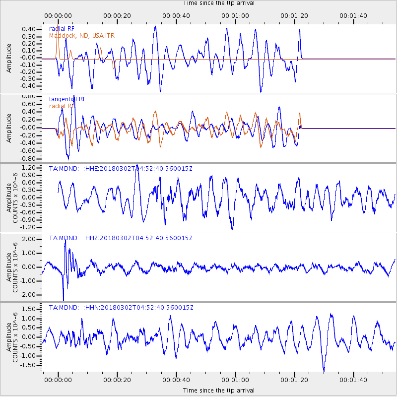
MDND Maddock, ND, USA - Earthquake Result Viewer
*The percent match for this event was below the threshold and hence no stack was calculated.
| Earthquake location: |
Salta Province, Argentina |
| Earthquake latitude/longitude: |
-22.1/-63.8 |
| Earthquake time(UTC): |
2018/03/02 (061) 04:42:14 GMT |
| Earthquake Depth: |
526 km |
| Earthquake Magnitude: |
5.4 Mww |
| Earthquake Catalog/Contributor: |
NEIC PDE/us |
|
| Network: |
TA USArray Transportable Network (new EarthScope stations) |
| Station: |
MDND Maddock, ND, USA |
| Lat/Lon: |
47.85 N/99.60 W |
| Elevation: |
479 m |
|
| Distance: |
76.7 deg |
| Az: |
336.091 deg |
| Baz: |
146.076 deg |
| Ray Param: |
$rayparam |
*The percent match for this event was below the threshold and hence was not used in the summary stack. |
|
| Radial Match: |
41.63163 % |
| Radial Bump: |
400 |
| Transverse Match: |
65.2553 % |
| Transverse Bump: |
400 |
| SOD ConfigId: |
13570011 |
| Insert Time: |
2019-04-29 21:47:02.166 +0000 |
| GWidth: |
2.5 |
| Max Bumps: |
400 |
| Tol: |
0.001 |
|
Signal To Noise
| Channel | StoN | STA | LTA |
| TA:MDND: :HHZ:20180302T04:52:40.560015Z | 5.2775226 | 8.98407E-7 | 1.7023271E-7 |
| TA:MDND: :HHN:20180302T04:52:40.560015Z | 0.816158 | 2.7599685E-7 | 3.3816596E-7 |
| TA:MDND: :HHE:20180302T04:52:40.560015Z | 1.4331543 | 4.9415735E-7 | 3.4480402E-7 |
| Arrivals |
| Ps | |
| PpPs | |
| PsPs/PpSs | |


