You are here: Home > Network List > TA - USArray Transportable Network (new EarthScope stations) Stations List
> Station E18K Tukpahlearik Creek, AK, USA > Earthquake Result Viewer
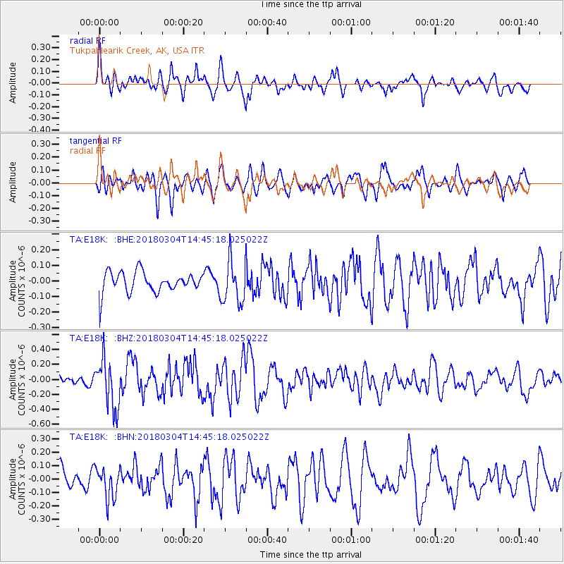
E18K Tukpahlearik Creek, AK, USA - Earthquake Result Viewer
*The percent match for this event was below the threshold and hence no stack was calculated.
| Earthquake location: |
New Guinea, Papua New Guinea |
| Earthquake latitude/longitude: |
-6.1/142.7 |
| Earthquake time(UTC): |
2018/03/04 (063) 14:33:21 GMT |
| Earthquake Depth: |
6.0 km |
| Earthquake Magnitude: |
5.7 Mww |
| Earthquake Catalog/Contributor: |
NEIC PDE/us |
|
| Network: |
TA USArray Transportable Network (new EarthScope stations) |
| Station: |
E18K Tukpahlearik Creek, AK, USA |
| Lat/Lon: |
67.42 N/160.60 W |
| Elevation: |
297 m |
|
| Distance: |
83.5 deg |
| Az: |
18.952 deg |
| Baz: |
236.762 deg |
| Ray Param: |
$rayparam |
*The percent match for this event was below the threshold and hence was not used in the summary stack. |
|
| Radial Match: |
62.055298 % |
| Radial Bump: |
400 |
| Transverse Match: |
59.41684 % |
| Transverse Bump: |
400 |
| SOD ConfigId: |
13570011 |
| Insert Time: |
2019-04-29 21:51:23.084 +0000 |
| GWidth: |
2.5 |
| Max Bumps: |
400 |
| Tol: |
0.001 |
|
Signal To Noise
| Channel | StoN | STA | LTA |
| TA:E18K: :BHZ:20180304T14:45:18.025022Z | 3.746327 | 3.3241918E-7 | 8.873202E-8 |
| TA:E18K: :BHN:20180304T14:45:18.025022Z | 1.1722281 | 1.13704296E-7 | 9.6998434E-8 |
| TA:E18K: :BHE:20180304T14:45:18.025022Z | 2.1016142 | 1.3838654E-7 | 6.5847736E-8 |
| Arrivals |
| Ps | |
| PpPs | |
| PsPs/PpSs | |


