You are here: Home > Network List > TA - USArray Transportable Network (new EarthScope stations) Stations List
> Station H16A Russell Place, West Yellowstone, MT, USA > Earthquake Result Viewer
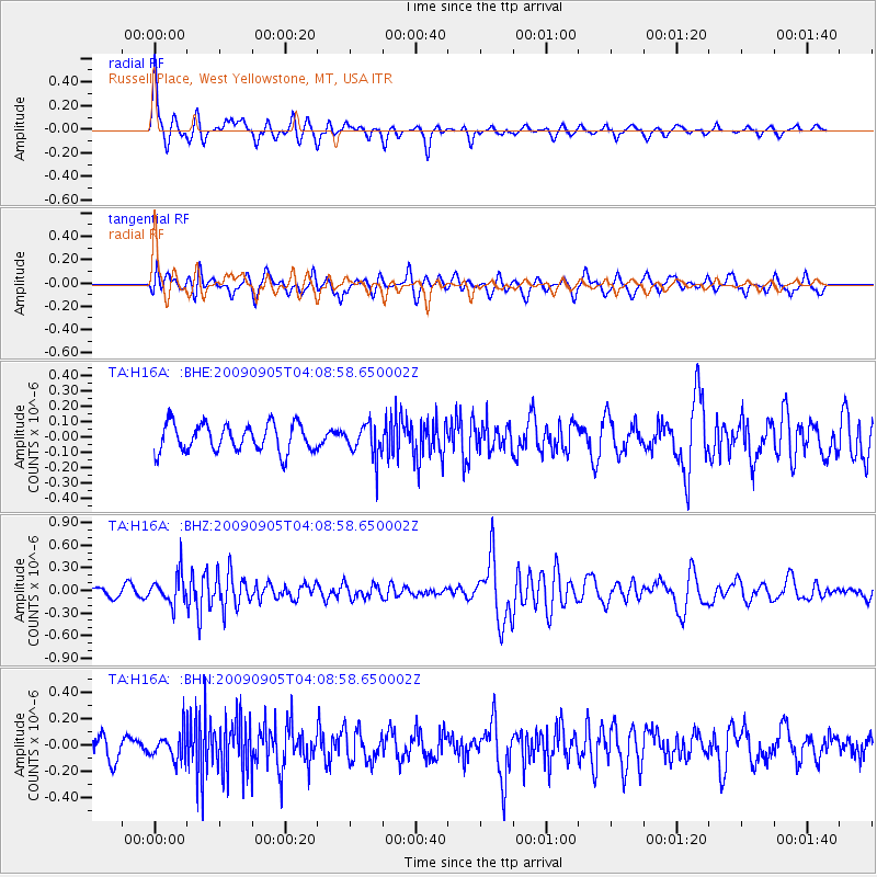
H16A Russell Place, West Yellowstone, MT, USA - Earthquake Result Viewer
*The percent match for this event was below the threshold and hence no stack was calculated.
| Earthquake location: |
Southern Peru |
| Earthquake latitude/longitude: |
-15.1/-70.2 |
| Earthquake time(UTC): |
2009/09/05 (248) 03:58:39 GMT |
| Earthquake Depth: |
210 km |
| Earthquake Magnitude: |
5.8 MW, 5.2 MB, 5.8 MW |
| Earthquake Catalog/Contributor: |
WHDF/NEIC |
|
| Network: |
TA USArray Transportable Network (new EarthScope stations) |
| Station: |
H16A Russell Place, West Yellowstone, MT, USA |
| Lat/Lon: |
44.70 N/111.25 W |
| Elevation: |
2080 m |
|
| Distance: |
70.2 deg |
| Az: |
330.191 deg |
| Baz: |
137.68 deg |
| Ray Param: |
$rayparam |
*The percent match for this event was below the threshold and hence was not used in the summary stack. |
|
| Radial Match: |
69.169304 % |
| Radial Bump: |
285 |
| Transverse Match: |
56.976643 % |
| Transverse Bump: |
400 |
| SOD ConfigId: |
2622 |
| Insert Time: |
2010-03-06 09:33:06.846 +0000 |
| GWidth: |
2.5 |
| Max Bumps: |
400 |
| Tol: |
0.001 |
|
Signal To Noise
| Channel | StoN | STA | LTA |
| TA:H16A: :BHZ:20090905T04:08:58.650002Z | 2.165192 | 1.9298777E-7 | 8.913195E-8 |
| TA:H16A: :BHN:20090905T04:08:58.650002Z | 1.1571887 | 1.0070899E-7 | 8.7029015E-8 |
| TA:H16A: :BHE:20090905T04:08:58.650002Z | 1.207938 | 1.0805012E-7 | 8.945006E-8 |
| Arrivals |
| Ps | |
| PpPs | |
| PsPs/PpSs | |


