You are here: Home > Network List > CI - Caltech Regional Seismic Network Stations List
> Station JCS Julian Camp Stevens, California, USA > Earthquake Result Viewer
JCS Julian Camp Stevens, California, USA - Earthquake Result Viewer
| Earthquake location: |
Tonga Islands |
| Earthquake latitude/longitude: |
-20.1/-175.7 |
| Earthquake time(UTC): |
2006/03/05 (064) 08:07:56 GMT |
| Earthquake Depth: |
206 km |
| Earthquake Magnitude: |
6.0 MB, 6.1 MW, 6.0 MW |
| Earthquake Catalog/Contributor: |
WHDF/NEIC |
|
| Network: |
CI Caltech Regional Seismic Network |
| Station: |
JCS Julian Camp Stevens, California, USA |
| Lat/Lon: |
33.09 N/116.60 W |
| Elevation: |
1258 m |
|
| Distance: |
77.3 deg |
| Az: |
47.574 deg |
| Baz: |
235.716 deg |
| Ray Param: |
0.04988105 |
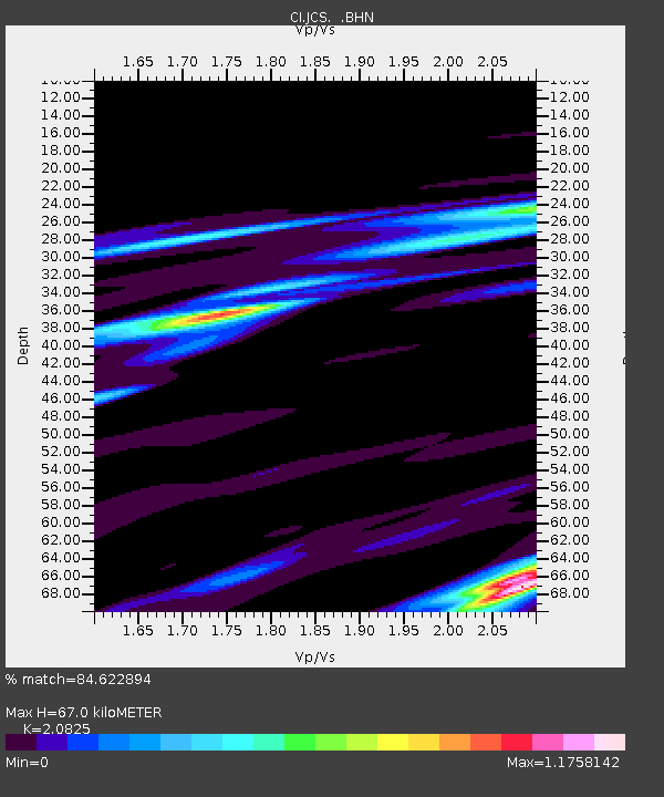
| Estimated Moho Depth: |
67.0 km |
| Estimated Crust Vp/Vs: |
2.08 |
| Assumed Crust Vp: |
6.264 km/s |
| Estimated Crust Vs: |
3.008 km/s |
| Estimated Crust Poisson's Ratio: |
0.35 |
|
| Radial Match: |
84.622894 % |
| Radial Bump: |
400 |
| Transverse Match: |
57.823364 % |
| Transverse Bump: |
400 |
| SOD ConfigId: |
2422 |
| Insert Time: |
2010-02-26 01:50:53.261 +0000 |
| GWidth: |
2.5 |
| Max Bumps: |
400 |
| Tol: |
0.001 |
|
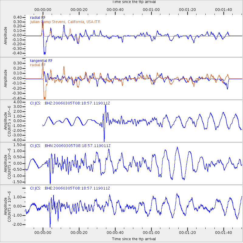
Signal To Noise
| Channel | StoN | STA | LTA |
| CI:JCS: :BHN:20060305T08:18:57.119011Z | 1.0636945 | 4.5916468E-7 | 4.3166972E-7 |
| CI:JCS: :BHE:20060305T08:18:57.119011Z | 1.4446024 | 6.3224877E-7 | 4.3766283E-7 |
| CI:JCS: :BHZ:20060305T08:18:57.119011Z | 2.692151 | 1.463591E-6 | 5.4365114E-7 |
| Arrivals |
| Ps | 12 SECOND |
| PpPs | 32 SECOND |
| PsPs/PpSs | 44 SECOND |


