You are here: Home > Network List > TA - USArray Transportable Network (new EarthScope stations) Stations List
> Station H16A Russell Place, West Yellowstone, MT, USA > Earthquake Result Viewer
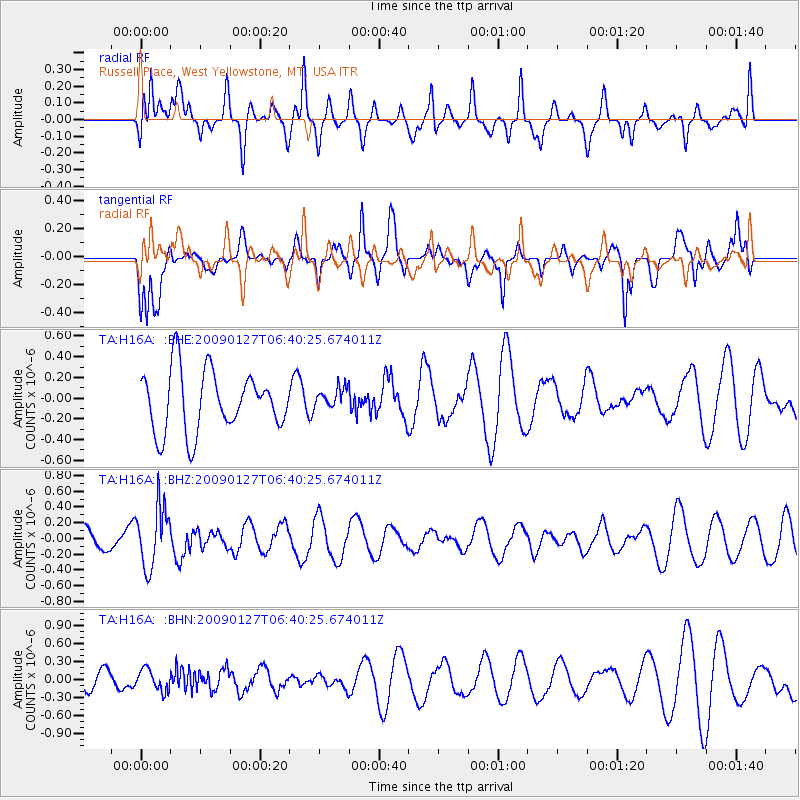
H16A Russell Place, West Yellowstone, MT, USA - Earthquake Result Viewer
*The percent match for this event was below the threshold and hence no stack was calculated.
| Earthquake location: |
Fiji Islands Region |
| Earthquake latitude/longitude: |
-17.8/-178.7 |
| Earthquake time(UTC): |
2009/01/27 (027) 06:29:13 GMT |
| Earthquake Depth: |
601 km |
| Earthquake Magnitude: |
5.9 MW, 5.1 MB, 5.8 MW |
| Earthquake Catalog/Contributor: |
WHDF/NEIC |
|
| Network: |
TA USArray Transportable Network (new EarthScope stations) |
| Station: |
H16A Russell Place, West Yellowstone, MT, USA |
| Lat/Lon: |
44.70 N/111.25 W |
| Elevation: |
2080 m |
|
| Distance: |
87.3 deg |
| Az: |
41.241 deg |
| Baz: |
241.709 deg |
| Ray Param: |
$rayparam |
*The percent match for this event was below the threshold and hence was not used in the summary stack. |
|
| Radial Match: |
70.27411 % |
| Radial Bump: |
400 |
| Transverse Match: |
57.45344 % |
| Transverse Bump: |
334 |
| SOD ConfigId: |
2658 |
| Insert Time: |
2010-03-06 09:34:17.135 +0000 |
| GWidth: |
2.5 |
| Max Bumps: |
400 |
| Tol: |
0.001 |
|
Signal To Noise
| Channel | StoN | STA | LTA |
| TA:H16A: :BHZ:20090127T06:40:25.674011Z | 2.461555 | 3.8718605E-7 | 1.5729326E-7 |
| TA:H16A: :BHN:20090127T06:40:25.674011Z | 0.93709266 | 1.7853478E-7 | 1.9051988E-7 |
| TA:H16A: :BHE:20090127T06:40:25.674011Z | 0.3498688 | 1.0215167E-7 | 2.9197136E-7 |
| Arrivals |
| Ps | |
| PpPs | |
| PsPs/PpSs | |


