You are here: Home > Network List > TA - USArray Transportable Network (new EarthScope stations) Stations List
> Station H16A Russell Place, West Yellowstone, MT, USA > Earthquake Result Viewer
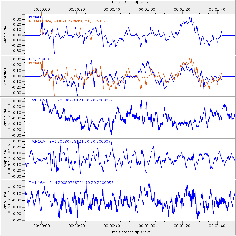
H16A Russell Place, West Yellowstone, MT, USA - Earthquake Result Viewer
*The percent match for this event was below the threshold and hence no stack was calculated.
| Earthquake location: |
Solomon Islands |
| Earthquake latitude/longitude: |
-10.6/163.2 |
| Earthquake time(UTC): |
2008/07/28 (210) 21:37:32 GMT |
| Earthquake Depth: |
10 km |
| Earthquake Magnitude: |
5.7 MB, 6.1 MS, 5.9 MW |
| Earthquake Catalog/Contributor: |
WHDF/NEIC |
|
| Network: |
TA USArray Transportable Network (new EarthScope stations) |
| Station: |
H16A Russell Place, West Yellowstone, MT, USA |
| Lat/Lon: |
44.70 N/111.25 W |
| Elevation: |
2080 m |
|
| Distance: |
94.3 deg |
| Az: |
45.477 deg |
| Baz: |
259.403 deg |
| Ray Param: |
$rayparam |
*The percent match for this event was below the threshold and hence was not used in the summary stack. |
|
| Radial Match: |
31.199402 % |
| Radial Bump: |
400 |
| Transverse Match: |
40.800472 % |
| Transverse Bump: |
400 |
| SOD ConfigId: |
2658 |
| Insert Time: |
2010-03-06 09:34:21.260 +0000 |
| GWidth: |
2.5 |
| Max Bumps: |
400 |
| Tol: |
0.001 |
|
Signal To Noise
| Channel | StoN | STA | LTA |
| TA:H16A: :BHZ:20080728T21:50:20.200005Z | 0.59065455 | 5.296448E-8 | 8.967083E-8 |
| TA:H16A: :BHN:20080728T21:50:20.200005Z | 1.6826357 | 1.1685031E-7 | 6.94448E-8 |
| TA:H16A: :BHE:20080728T21:50:20.200005Z | 1.419222 | 1.7188572E-7 | 1.2111263E-7 |
| Arrivals |
| Ps | |
| PpPs | |
| PsPs/PpSs | |


