You are here: Home > Network List > TA - USArray Transportable Network (new EarthScope stations) Stations List
> Station C16K Lisburne Hills, AK, USA > Earthquake Result Viewer
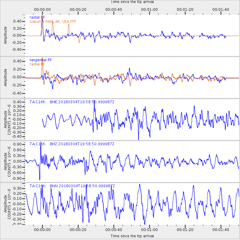
C16K Lisburne Hills, AK, USA - Earthquake Result Viewer
*The percent match for this event was below the threshold and hence no stack was calculated.
| Earthquake location: |
Kuril Islands |
| Earthquake latitude/longitude: |
45.1/147.8 |
| Earthquake time(UTC): |
2018/03/04 (063) 19:52:52 GMT |
| Earthquake Depth: |
104 km |
| Earthquake Magnitude: |
5.4 Mww |
| Earthquake Catalog/Contributor: |
NEIC PDE/us |
|
| Network: |
TA USArray Transportable Network (new EarthScope stations) |
| Station: |
C16K Lisburne Hills, AK, USA |
| Lat/Lon: |
68.27 N/165.34 W |
| Elevation: |
102 m |
|
| Distance: |
33.4 deg |
| Az: |
29.599 deg |
| Baz: |
250.109 deg |
| Ray Param: |
$rayparam |
*The percent match for this event was below the threshold and hence was not used in the summary stack. |
|
| Radial Match: |
54.948498 % |
| Radial Bump: |
400 |
| Transverse Match: |
37.020107 % |
| Transverse Bump: |
400 |
| SOD ConfigId: |
13570011 |
| Insert Time: |
2019-04-29 22:00:59.454 +0000 |
| GWidth: |
2.5 |
| Max Bumps: |
400 |
| Tol: |
0.001 |
|
Signal To Noise
| Channel | StoN | STA | LTA |
| TA:C16K: :BHZ:20180304T19:58:50.999987Z | 2.1090512 | 2.8663806E-7 | 1.3590854E-7 |
| TA:C16K: :BHN:20180304T19:58:50.999987Z | 1.5604461 | 1.6400341E-7 | 1.0510033E-7 |
| TA:C16K: :BHE:20180304T19:58:50.999987Z | 1.6347245 | 1.4300683E-7 | 8.748069E-8 |
| Arrivals |
| Ps | |
| PpPs | |
| PsPs/PpSs | |


