You are here: Home > Network List > TA - USArray Transportable Network (new EarthScope stations) Stations List
> Station G21K Allakaket, AK, USA > Earthquake Result Viewer
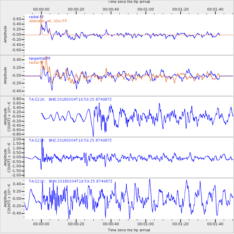
G21K Allakaket, AK, USA - Earthquake Result Viewer
*The percent match for this event was below the threshold and hence no stack was calculated.
| Earthquake location: |
Kuril Islands |
| Earthquake latitude/longitude: |
45.1/147.8 |
| Earthquake time(UTC): |
2018/03/04 (063) 19:52:52 GMT |
| Earthquake Depth: |
104 km |
| Earthquake Magnitude: |
5.4 Mww |
| Earthquake Catalog/Contributor: |
NEIC PDE/us |
|
| Network: |
TA USArray Transportable Network (new EarthScope stations) |
| Station: |
G21K Allakaket, AK, USA |
| Lat/Lon: |
66.52 N/153.51 W |
| Elevation: |
446 m |
|
| Distance: |
37.5 deg |
| Az: |
34.272 deg |
| Baz: |
264.844 deg |
| Ray Param: |
$rayparam |
*The percent match for this event was below the threshold and hence was not used in the summary stack. |
|
| Radial Match: |
60.117535 % |
| Radial Bump: |
400 |
| Transverse Match: |
65.99863 % |
| Transverse Bump: |
400 |
| SOD ConfigId: |
13570011 |
| Insert Time: |
2019-04-29 22:01:34.844 +0000 |
| GWidth: |
2.5 |
| Max Bumps: |
400 |
| Tol: |
0.001 |
|
Signal To Noise
| Channel | StoN | STA | LTA |
| TA:G21K: :BHZ:20180304T19:59:25.874987Z | 5.389483 | 6.2440125E-7 | 1.158555E-7 |
| TA:G21K: :BHN:20180304T19:59:25.874987Z | 0.93245965 | 1.7121786E-7 | 1.8361959E-7 |
| TA:G21K: :BHE:20180304T19:59:25.874987Z | 3.2700918 | 4.0226053E-7 | 1.23012E-7 |
| Arrivals |
| Ps | |
| PpPs | |
| PsPs/PpSs | |


