You are here: Home > Network List > TA - USArray Transportable Network (new EarthScope stations) Stations List
> Station I30M Mount Dempster, Yukon, CAN > Earthquake Result Viewer
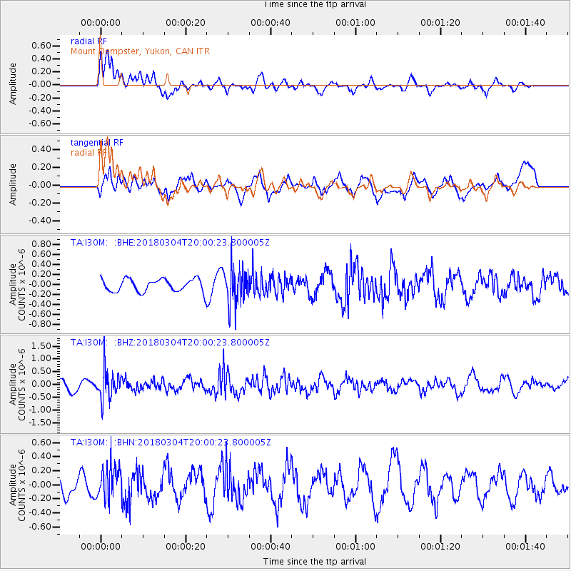
I30M Mount Dempster, Yukon, CAN - Earthquake Result Viewer
*The percent match for this event was below the threshold and hence no stack was calculated.
| Earthquake location: |
Kuril Islands |
| Earthquake latitude/longitude: |
45.1/147.8 |
| Earthquake time(UTC): |
2018/03/04 (063) 19:52:52 GMT |
| Earthquake Depth: |
104 km |
| Earthquake Magnitude: |
5.4 Mww |
| Earthquake Catalog/Contributor: |
NEIC PDE/us |
|
| Network: |
TA USArray Transportable Network (new EarthScope stations) |
| Station: |
I30M Mount Dempster, Yukon, CAN |
| Lat/Lon: |
65.22 N/136.38 W |
| Elevation: |
1399 m |
|
| Distance: |
44.5 deg |
| Az: |
35.634 deg |
| Baz: |
281.51 deg |
| Ray Param: |
$rayparam |
*The percent match for this event was below the threshold and hence was not used in the summary stack. |
|
| Radial Match: |
75.52835 % |
| Radial Bump: |
400 |
| Transverse Match: |
65.16281 % |
| Transverse Bump: |
400 |
| SOD ConfigId: |
13570011 |
| Insert Time: |
2019-04-29 22:01:52.228 +0000 |
| GWidth: |
2.5 |
| Max Bumps: |
400 |
| Tol: |
0.001 |
|
Signal To Noise
| Channel | StoN | STA | LTA |
| TA:I30M: :BHZ:20180304T20:00:23.800005Z | 3.8282497 | 5.644425E-7 | 1.4744138E-7 |
| TA:I30M: :BHN:20180304T20:00:23.800005Z | 1.8649678 | 2.4160937E-7 | 1.2955151E-7 |
| TA:I30M: :BHE:20180304T20:00:23.800005Z | 2.7394545 | 3.455825E-7 | 1.2615011E-7 |
| Arrivals |
| Ps | |
| PpPs | |
| PsPs/PpSs | |


