You are here: Home > Network List > WY - Yellowstone Wyoming Seismic Network Stations List
> Station YHH Holmes Hill, YNP, WY, USA > Earthquake Result Viewer
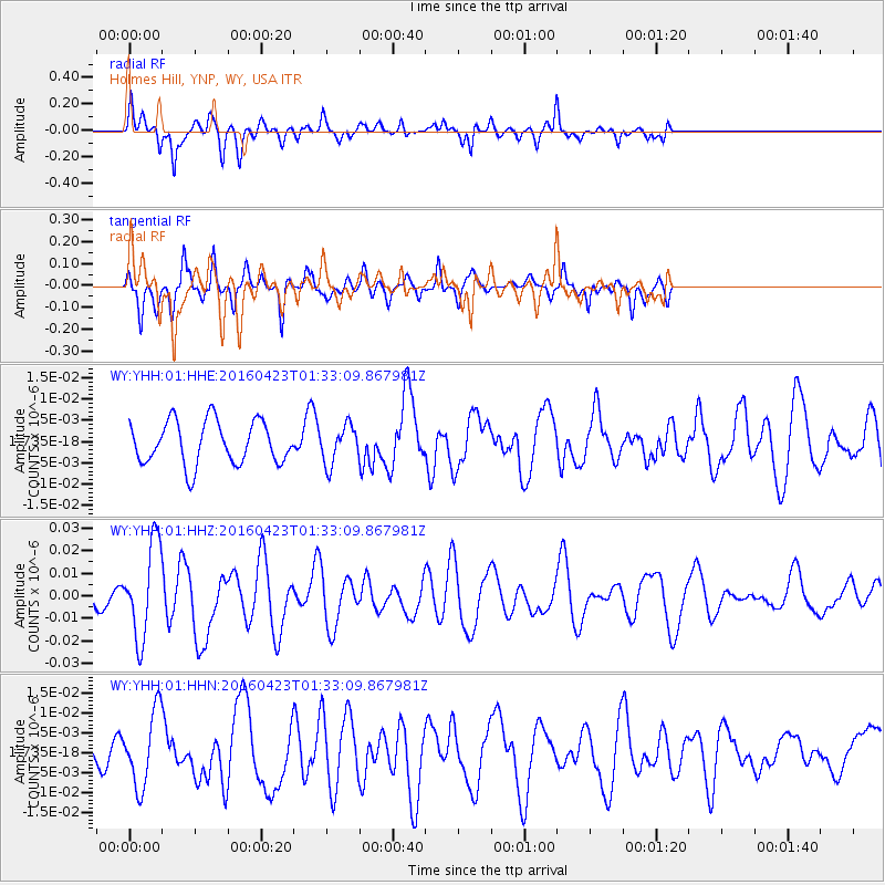
YHH Holmes Hill, YNP, WY, USA - Earthquake Result Viewer
| Earthquake location: |
Near Coast Of Ecuador |
| Earthquake latitude/longitude: |
0.6/-80.3 |
| Earthquake time(UTC): |
2016/04/23 (114) 01:24:34 GMT |
| Earthquake Depth: |
10 km |
| Earthquake Magnitude: |
5.8 MWP |
| Earthquake Catalog/Contributor: |
NEIC PDE/NEIC COMCAT |
|
| Network: |
WY Yellowstone Wyoming Seismic Network |
| Station: |
YHH Holmes Hill, YNP, WY, USA |
| Lat/Lon: |
44.79 N/110.85 W |
| Elevation: |
2717 m |
|
| Distance: |
51.7 deg |
| Az: |
332.492 deg |
| Baz: |
139.564 deg |
| Ray Param: |
0.0672684 |
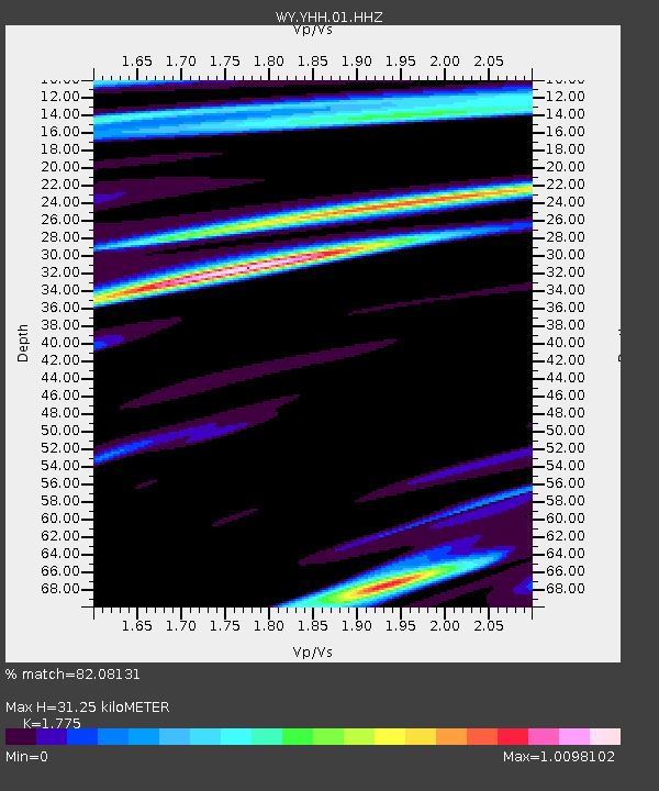
| Estimated Moho Depth: |
31.25 km |
| Estimated Crust Vp/Vs: |
1.77 |
| Assumed Crust Vp: |
6.35 km/s |
| Estimated Crust Vs: |
3.577 km/s |
| Estimated Crust Poisson's Ratio: |
0.27 |
|
| Radial Match: |
82.08131 % |
| Radial Bump: |
400 |
| Transverse Match: |
61.49403 % |
| Transverse Bump: |
362 |
| SOD ConfigId: |
1475611 |
| Insert Time: |
2016-05-07 01:37:06.248 +0000 |
| GWidth: |
2.5 |
| Max Bumps: |
400 |
| Tol: |
0.001 |
|
Signal To Noise
| Channel | StoN | STA | LTA |
| WY:YHH:01:HHZ:20160423T01:33:09.867981Z | 4.7749553 | 2.0612374E-8 | 4.316768E-9 |
| WY:YHH:01:HHN:20160423T01:33:09.867981Z | 2.7973576 | 9.225131E-9 | 3.2978018E-9 |
| WY:YHH:01:HHE:20160423T01:33:09.867981Z | 0.8875255 | 4.4647894E-9 | 5.030604E-9 |
| Arrivals |
| Ps | 4.0 SECOND |
| PpPs | 13 SECOND |
| PsPs/PpSs | 17 SECOND |


