You are here: Home > Network List > TA - USArray Transportable Network (new EarthScope stations) Stations List
> Station O17K Koliganek, Bristol Bay, AK, USA > Earthquake Result Viewer
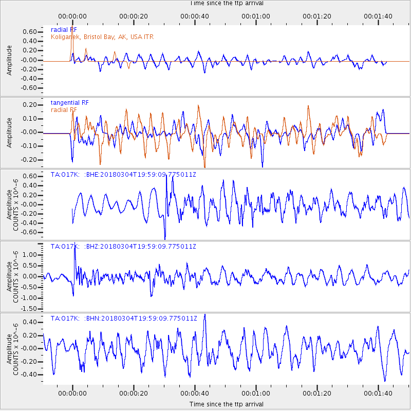
O17K Koliganek, Bristol Bay, AK, USA - Earthquake Result Viewer
*The percent match for this event was below the threshold and hence no stack was calculated.
| Earthquake location: |
Kuril Islands |
| Earthquake latitude/longitude: |
45.1/147.8 |
| Earthquake time(UTC): |
2018/03/04 (063) 19:52:52 GMT |
| Earthquake Depth: |
104 km |
| Earthquake Magnitude: |
5.4 Mww |
| Earthquake Catalog/Contributor: |
NEIC PDE/us |
|
| Network: |
TA USArray Transportable Network (new EarthScope stations) |
| Station: |
O17K Koliganek, Bristol Bay, AK, USA |
| Lat/Lon: |
59.77 N/157.09 W |
| Elevation: |
156 m |
|
| Distance: |
35.6 deg |
| Az: |
45.542 deg |
| Baz: |
270.712 deg |
| Ray Param: |
$rayparam |
*The percent match for this event was below the threshold and hence was not used in the summary stack. |
|
| Radial Match: |
43.093727 % |
| Radial Bump: |
400 |
| Transverse Match: |
47.717575 % |
| Transverse Bump: |
400 |
| SOD ConfigId: |
13570011 |
| Insert Time: |
2019-04-29 22:02:13.963 +0000 |
| GWidth: |
2.5 |
| Max Bumps: |
400 |
| Tol: |
0.001 |
|
Signal To Noise
| Channel | StoN | STA | LTA |
| TA:O17K: :BHZ:20180304T19:59:09.775011Z | 3.3527057 | 4.5819968E-7 | 1.3666563E-7 |
| TA:O17K: :BHN:20180304T19:59:09.775011Z | 0.9206747 | 1.5615106E-7 | 1.6960503E-7 |
| TA:O17K: :BHE:20180304T19:59:09.775011Z | 2.0702438 | 3.25894E-7 | 1.5741817E-7 |
| Arrivals |
| Ps | |
| PpPs | |
| PsPs/PpSs | |


