You are here: Home > Network List > TA - USArray Transportable Network (new EarthScope stations) Stations List
> Station P17K Kvichak River, AK, USA > Earthquake Result Viewer
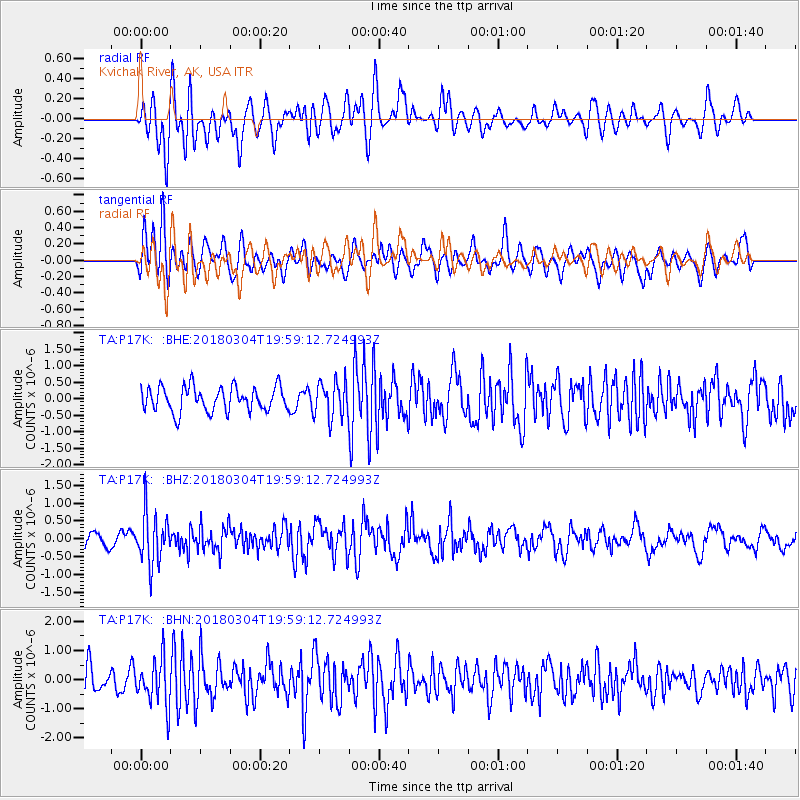
P17K Kvichak River, AK, USA - Earthquake Result Viewer
*The percent match for this event was below the threshold and hence no stack was calculated.
| Earthquake location: |
Kuril Islands |
| Earthquake latitude/longitude: |
45.1/147.8 |
| Earthquake time(UTC): |
2018/03/04 (063) 19:52:52 GMT |
| Earthquake Depth: |
104 km |
| Earthquake Magnitude: |
5.4 Mww |
| Earthquake Catalog/Contributor: |
NEIC PDE/us |
|
| Network: |
TA USArray Transportable Network (new EarthScope stations) |
| Station: |
P17K Kvichak River, AK, USA |
| Lat/Lon: |
59.20 N/156.44 W |
| Elevation: |
91 m |
|
| Distance: |
35.9 deg |
| Az: |
46.521 deg |
| Baz: |
272.07 deg |
| Ray Param: |
$rayparam |
*The percent match for this event was below the threshold and hence was not used in the summary stack. |
|
| Radial Match: |
61.784534 % |
| Radial Bump: |
400 |
| Transverse Match: |
65.960144 % |
| Transverse Bump: |
400 |
| SOD ConfigId: |
13570011 |
| Insert Time: |
2019-04-29 22:02:17.352 +0000 |
| GWidth: |
2.5 |
| Max Bumps: |
400 |
| Tol: |
0.001 |
|
Signal To Noise
| Channel | StoN | STA | LTA |
| TA:P17K: :BHZ:20180304T19:59:12.724993Z | 3.0172362 | 7.102726E-7 | 2.3540504E-7 |
| TA:P17K: :BHN:20180304T19:59:12.724993Z | 1.6379031 | 8.0090825E-7 | 4.889839E-7 |
| TA:P17K: :BHE:20180304T19:59:12.724993Z | 1.475024 | 5.512662E-7 | 3.7373377E-7 |
| Arrivals |
| Ps | |
| PpPs | |
| PsPs/PpSs | |


