You are here: Home > Network List > TA - USArray Transportable Network (new EarthScope stations) Stations List
> Station C09A Chrisman Ranch, Davenport, WA, USA > Earthquake Result Viewer
C09A Chrisman Ranch, Davenport, WA, USA - Earthquake Result Viewer
| Earthquake location: |
Off Coast Of Jalisco, Mexico |
| Earthquake latitude/longitude: |
17.6/-105.5 |
| Earthquake time(UTC): |
2008/09/24 (268) 02:33:05 GMT |
| Earthquake Depth: |
10 km |
| Earthquake Magnitude: |
5.7 MB, 6.2 MS, 6.4 MW, 6.4 MW |
| Earthquake Catalog/Contributor: |
WHDF/NEIC |
|
| Network: |
TA USArray Transportable Network (new EarthScope stations) |
| Station: |
C09A Chrisman Ranch, Davenport, WA, USA |
| Lat/Lon: |
47.80 N/118.27 W |
| Elevation: |
495 m |
|
| Distance: |
31.9 deg |
| Az: |
343.607 deg |
| Baz: |
156.469 deg |
| Ray Param: |
0.078887634 |
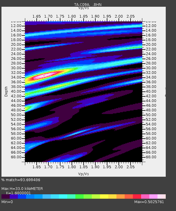
| Estimated Moho Depth: |
33.0 km |
| Estimated Crust Vp/Vs: |
1.68 |
| Assumed Crust Vp: |
6.419 km/s |
| Estimated Crust Vs: |
3.821 km/s |
| Estimated Crust Poisson's Ratio: |
0.23 |
|
| Radial Match: |
93.699486 % |
| Radial Bump: |
302 |
| Transverse Match: |
71.50488 % |
| Transverse Bump: |
400 |
| SOD ConfigId: |
2560 |
| Insert Time: |
2010-03-06 09:35:22.159 +0000 |
| GWidth: |
2.5 |
| Max Bumps: |
400 |
| Tol: |
0.001 |
|

Signal To Noise
| Channel | StoN | STA | LTA |
| TA:C09A: :BHN:20080924T02:38:59.825011Z | 28.343155 | 1.7299798E-6 | 6.103695E-8 |
| TA:C09A: :BHE:20080924T02:38:59.825011Z | 12.101105 | 1.116893E-6 | 9.229679E-8 |
| TA:C09A: :BHZ:20080924T02:38:59.825011Z | 4.596658 | 5.0611175E-7 | 1.1010429E-7 |
| Arrivals |
| Ps | 3.8 SECOND |
| PpPs | 13 SECOND |
| PsPs/PpSs | 16 SECOND |


