You are here: Home > Network List > TA - USArray Transportable Network (new EarthScope stations) Stations List
> Station C09A Chrisman Ranch, Davenport, WA, USA > Earthquake Result Viewer
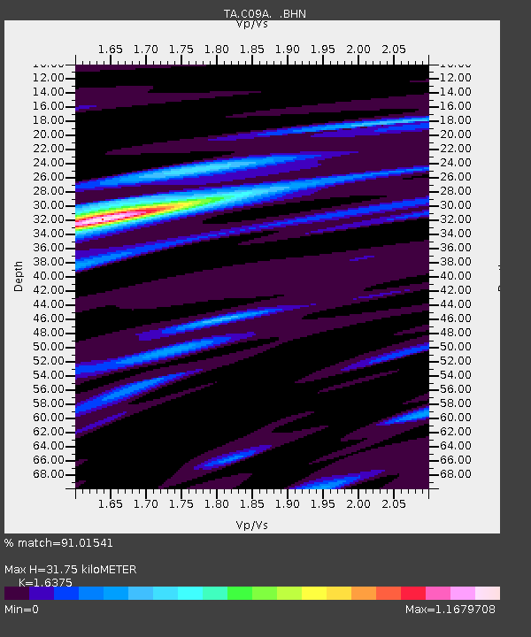
C09A Chrisman Ranch, Davenport, WA, USA - Earthquake Result Viewer
| Earthquake location: |
Hokkaido, Japan Region |
| Earthquake latitude/longitude: |
41.9/143.8 |
| Earthquake time(UTC): |
2008/09/11 (255) 00:20:50 GMT |
| Earthquake Depth: |
25 km |
| Earthquake Magnitude: |
6.1 MB, 7.0 MS, 6.8 MW, 6.8 MW |
| Earthquake Catalog/Contributor: |
WHDF/NEIC |
|
| Network: |
TA USArray Transportable Network (new EarthScope stations) |
| Station: |
C09A Chrisman Ranch, Davenport, WA, USA |
| Lat/Lon: |
47.80 N/118.27 W |
| Elevation: |
495 m |
|
| Distance: |
65.1 deg |
| Az: |
47.415 deg |
| Baz: |
305.374 deg |
| Ray Param: |
0.058479916 |
| Estimated Moho Depth: |
31.75 km |
| Estimated Crust Vp/Vs: |
1.64 |
| Assumed Crust Vp: |
6.419 km/s |
| Estimated Crust Vs: |
3.92 km/s |
| Estimated Crust Poisson's Ratio: |
0.20 |
|
| Radial Match: |
91.01541 % |
| Radial Bump: |
357 |
| Transverse Match: |
80.55418 % |
| Transverse Bump: |
400 |
| SOD ConfigId: |
2504 |
| Insert Time: |
2010-03-06 09:35:36.974 +0000 |
| GWidth: |
2.5 |
| Max Bumps: |
400 |
| Tol: |
0.001 |
|

Signal To Noise
| Channel | StoN | STA | LTA |
| TA:C09A: :BHN:20080911T00:30:58.125017Z | 3.329588 | 7.393838E-7 | 2.2206464E-7 |
| TA:C09A: :BHE:20080911T00:30:58.125017Z | 2.063597 | 3.2298527E-7 | 1.5651568E-7 |
| TA:C09A: :BHZ:20080911T00:30:58.125017Z | 2.6499786 | 6.943617E-7 | 2.620254E-7 |
| Arrivals |
| Ps | 3.3 SECOND |
| PpPs | 12 SECOND |
| PsPs/PpSs | 16 SECOND |


