You are here: Home > Network List > TA - USArray Transportable Network (new EarthScope stations) Stations List
> Station C09A Chrisman Ranch, Davenport, WA, USA > Earthquake Result Viewer
C09A Chrisman Ranch, Davenport, WA, USA - Earthquake Result Viewer
| Earthquake location: |
Central East Pacific Rise |
| Earthquake latitude/longitude: |
-4.6/-106.0 |
| Earthquake time(UTC): |
2008/09/18 (262) 01:41:02 GMT |
| Earthquake Depth: |
10 km |
| Earthquake Magnitude: |
5.5 MB, 5.7 MS, 6.0 MW, 6.0 MW |
| Earthquake Catalog/Contributor: |
WHDF/NEIC |
|
| Network: |
TA USArray Transportable Network (new EarthScope stations) |
| Station: |
C09A Chrisman Ranch, Davenport, WA, USA |
| Lat/Lon: |
47.80 N/118.27 W |
| Elevation: |
495 m |
|
| Distance: |
53.2 deg |
| Az: |
349.694 deg |
| Baz: |
164.661 deg |
| Ray Param: |
0.06623251 |
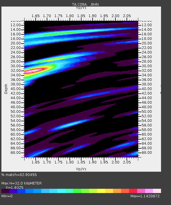
| Estimated Moho Depth: |
32.0 km |
| Estimated Crust Vp/Vs: |
1.63 |
| Assumed Crust Vp: |
6.419 km/s |
| Estimated Crust Vs: |
3.932 km/s |
| Estimated Crust Poisson's Ratio: |
0.20 |
|
| Radial Match: |
82.90455 % |
| Radial Bump: |
400 |
| Transverse Match: |
62.786156 % |
| Transverse Bump: |
400 |
| SOD ConfigId: |
2504 |
| Insert Time: |
2010-03-06 09:35:40.930 +0000 |
| GWidth: |
2.5 |
| Max Bumps: |
400 |
| Tol: |
0.001 |
|

Signal To Noise
| Channel | StoN | STA | LTA |
| TA:C09A: :BHN:20080918T01:49:50.399021Z | 3.1594288 | 2.7984598E-7 | 8.8574865E-8 |
| TA:C09A: :BHE:20080918T01:49:50.399021Z | 2.51335 | 1.8428372E-7 | 7.332195E-8 |
| TA:C09A: :BHZ:20080918T01:49:50.399021Z | 1.0542629 | 8.8416094E-8 | 8.386532E-8 |
| Arrivals |
| Ps | 3.3 SECOND |
| PpPs | 12 SECOND |
| PsPs/PpSs | 16 SECOND |


