You are here: Home > Network List > TA - USArray Transportable Network (new EarthScope stations) Stations List
> Station C09A Chrisman Ranch, Davenport, WA, USA > Earthquake Result Viewer
C09A Chrisman Ranch, Davenport, WA, USA - Earthquake Result Viewer
| Earthquake location: |
Andreanof Islands, Aleutian Is. |
| Earthquake latitude/longitude: |
51.4/-179.5 |
| Earthquake time(UTC): |
2007/12/19 (353) 09:30:27 GMT |
| Earthquake Depth: |
29 km |
| Earthquake Magnitude: |
6.4 MB, 7.1 MS, 7.1 MW, 7.0 MW |
| Earthquake Catalog/Contributor: |
WHDF/NEIC |
|
| Network: |
TA USArray Transportable Network (new EarthScope stations) |
| Station: |
C09A Chrisman Ranch, Davenport, WA, USA |
| Lat/Lon: |
47.80 N/118.27 W |
| Elevation: |
495 m |
|
| Distance: |
38.9 deg |
| Az: |
70.407 deg |
| Baz: |
298.827 deg |
| Ray Param: |
0.07526634 |
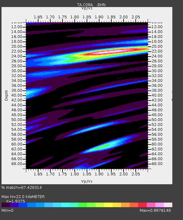
| Estimated Moho Depth: |
22.0 km |
| Estimated Crust Vp/Vs: |
1.94 |
| Assumed Crust Vp: |
6.419 km/s |
| Estimated Crust Vs: |
3.313 km/s |
| Estimated Crust Poisson's Ratio: |
0.32 |
|
| Radial Match: |
87.428314 % |
| Radial Bump: |
382 |
| Transverse Match: |
67.717064 % |
| Transverse Bump: |
400 |
| SOD ConfigId: |
2564 |
| Insert Time: |
2010-03-06 09:35:48.053 +0000 |
| GWidth: |
2.5 |
| Max Bumps: |
400 |
| Tol: |
0.001 |
|
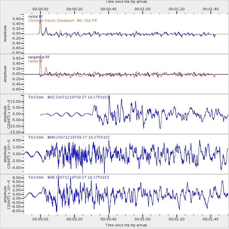
Signal To Noise
| Channel | StoN | STA | LTA |
| TA:C09A: :BHN:20071219T09:37:19.275015Z | 1.6312231 | 1.1574637E-6 | 7.09568E-7 |
| TA:C09A: :BHE:20071219T09:37:19.275015Z | 2.37476 | 2.1345177E-6 | 8.9883514E-7 |
| TA:C09A: :BHZ:20071219T09:37:19.275015Z | 4.258405 | 3.8107528E-6 | 8.948779E-7 |
| Arrivals |
| Ps | 3.4 SECOND |
| PpPs | 9.4 SECOND |
| PsPs/PpSs | 13 SECOND |


