You are here: Home > Network List > TA - USArray Transportable Network (new EarthScope stations) Stations List
> Station E20K Nigu River, AK, USA > Earthquake Result Viewer
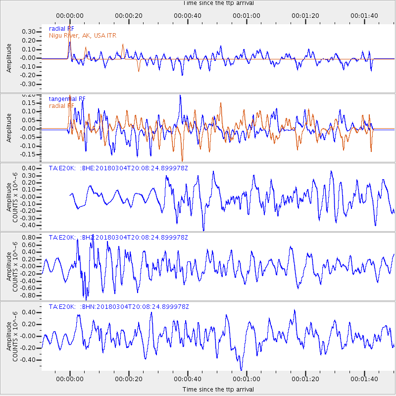
E20K Nigu River, AK, USA - Earthquake Result Viewer
*The percent match for this event was below the threshold and hence no stack was calculated.
| Earthquake location: |
New Guinea, Papua New Guinea |
| Earthquake latitude/longitude: |
-6.3/142.6 |
| Earthquake time(UTC): |
2018/03/04 (063) 19:56:18 GMT |
| Earthquake Depth: |
10 km |
| Earthquake Magnitude: |
6.0 Mww |
| Earthquake Catalog/Contributor: |
NEIC PDE/us |
|
| Network: |
TA USArray Transportable Network (new EarthScope stations) |
| Station: |
E20K Nigu River, AK, USA |
| Lat/Lon: |
68.26 N/156.19 W |
| Elevation: |
866 m |
|
| Distance: |
85.6 deg |
| Az: |
19.114 deg |
| Baz: |
240.881 deg |
| Ray Param: |
$rayparam |
*The percent match for this event was below the threshold and hence was not used in the summary stack. |
|
| Radial Match: |
60.17717 % |
| Radial Bump: |
400 |
| Transverse Match: |
66.57139 % |
| Transverse Bump: |
400 |
| SOD ConfigId: |
13570011 |
| Insert Time: |
2019-04-29 22:06:56.127 +0000 |
| GWidth: |
2.5 |
| Max Bumps: |
400 |
| Tol: |
0.001 |
|
Signal To Noise
| Channel | StoN | STA | LTA |
| TA:E20K: :BHZ:20180304T20:08:24.899978Z | 2.1876123 | 3.3028508E-7 | 1.5097972E-7 |
| TA:E20K: :BHN:20180304T20:08:24.899978Z | 1.9268061 | 1.9364985E-7 | 1.0050303E-7 |
| TA:E20K: :BHE:20180304T20:08:24.899978Z | 2.0809796 | 1.6571728E-7 | 7.963426E-8 |
| Arrivals |
| Ps | |
| PpPs | |
| PsPs/PpSs | |


