You are here: Home > Network List > GT - Global Telemetered Seismograph Network (USAF/USGS) Stations List
> Station LPAZ La Paz , Bolivia > Earthquake Result Viewer
LPAZ La Paz , Bolivia - Earthquake Result Viewer

| Earthquake location: |
South Sandwich Islands Region |
| Earthquake latitude/longitude: |
-59.3/-27.0 |
| Earthquake time(UTC): |
2016/04/24 (115) 08:38:00 GMT |
| Earthquake Depth: |
10 km |
| Earthquake Magnitude: |
5.5 MB |
| Earthquake Catalog/Contributor: |
NEIC PDE/NEIC COMCAT |
|
| Network: |
GT Global Telemetered Seismograph Network (USAF/USGS) |
| Station: |
LPAZ La Paz , Bolivia |
| Lat/Lon: |
16.17 S/68.08 W |
| Elevation: |
4817 m |
|
| Distance: |
52.5 deg |
| Az: |
307.26 deg |
| Baz: |
154.886 deg |
| Ray Param: |
0.066727355 |
| Estimated Moho Depth: |
27.25 km |
| Estimated Crust Vp/Vs: |
1.63 |
| Assumed Crust Vp: |
6.454 km/s |
| Estimated Crust Vs: |
3.953 km/s |
| Estimated Crust Poisson's Ratio: |
0.20 |
|
| Radial Match: |
84.19998 % |
| Radial Bump: |
400 |
| Transverse Match: |
78.58934 % |
| Transverse Bump: |
400 |
| SOD ConfigId: |
1475611 |
| Insert Time: |
2016-05-08 08:40:24.178 +0000 |
| GWidth: |
2.5 |
| Max Bumps: |
400 |
| Tol: |
0.001 |
|
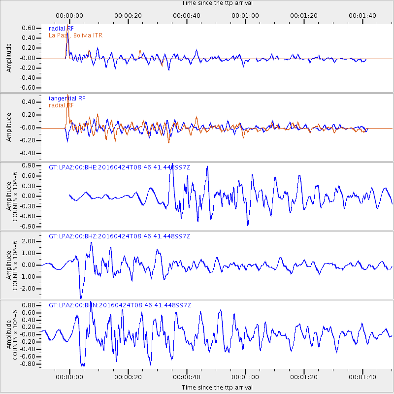
Signal To Noise
| Channel | StoN | STA | LTA |
| GT:LPAZ:00:BHZ:20160424T08:46:41.448997Z | 9.734555 | 1.2143012E-6 | 1.247413E-7 |
| GT:LPAZ:00:BHN:20160424T08:46:41.448997Z | 4.2016745 | 4.4007388E-7 | 1.0473774E-7 |
| GT:LPAZ:00:BHE:20160424T08:46:41.448997Z | 6.2259064 | 4.345438E-7 | 6.979607E-8 |
| Arrivals |
| Ps | 2.8 SECOND |
| PpPs | 10 SECOND |
| PsPs/PpSs | 13 SECOND |


