You are here: Home > Network List > CN - Canadian National Seismograph Network Stations List
> Station INK INUVIK, NT > Earthquake Result Viewer
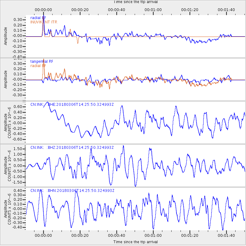
INK INUVIK, NT - Earthquake Result Viewer
*The percent match for this event was below the threshold and hence no stack was calculated.
| Earthquake location: |
New Guinea, Papua New Guinea |
| Earthquake latitude/longitude: |
-6.3/142.6 |
| Earthquake time(UTC): |
2018/03/06 (065) 14:13:06 GMT |
| Earthquake Depth: |
10 km |
| Earthquake Magnitude: |
6.7 Mww |
| Earthquake Catalog/Contributor: |
NEIC PDE/us |
|
| Network: |
CN Canadian National Seismograph Network |
| Station: |
INK INUVIK, NT |
| Lat/Lon: |
68.31 N/133.53 W |
| Elevation: |
44 m |
|
| Distance: |
93.5 deg |
| Az: |
21.738 deg |
| Baz: |
261.99 deg |
| Ray Param: |
$rayparam |
*The percent match for this event was below the threshold and hence was not used in the summary stack. |
|
| Radial Match: |
48.218437 % |
| Radial Bump: |
400 |
| Transverse Match: |
52.416306 % |
| Transverse Bump: |
400 |
| SOD ConfigId: |
13570011 |
| Insert Time: |
2019-04-29 22:10:17.433 +0000 |
| GWidth: |
2.5 |
| Max Bumps: |
400 |
| Tol: |
0.001 |
|
Signal To Noise
| Channel | StoN | STA | LTA |
| CN:INK: :BHZ:20180306T14:25:50.324993Z | 3.0744505 | 5.174757E-7 | 1.6831486E-7 |
| CN:INK: :BHN:20180306T14:25:50.324993Z | 1.2301258 | 2.4925217E-7 | 2.0262331E-7 |
| CN:INK: :BHE:20180306T14:25:50.324993Z | 0.9550761 | 3.7251948E-7 | 3.9004166E-7 |
| Arrivals |
| Ps | |
| PpPs | |
| PsPs/PpSs | |


