You are here: Home > Network List > TA - USArray Transportable Network (new EarthScope stations) Stations List
> Station C09A Chrisman Ranch, Davenport, WA, USA > Earthquake Result Viewer
C09A Chrisman Ranch, Davenport, WA, USA - Earthquake Result Viewer
| Earthquake location: |
Andreanof Islands, Aleutian Is. |
| Earthquake latitude/longitude: |
51.9/-179.2 |
| Earthquake time(UTC): |
2008/04/16 (107) 05:54:19 GMT |
| Earthquake Depth: |
13 km |
| Earthquake Magnitude: |
6.1 MB, 6.5 MS, 6.6 MW, 6.6 MW |
| Earthquake Catalog/Contributor: |
WHDF/NEIC |
|
| Network: |
TA USArray Transportable Network (new EarthScope stations) |
| Station: |
C09A Chrisman Ranch, Davenport, WA, USA |
| Lat/Lon: |
47.80 N/118.27 W |
| Elevation: |
495 m |
|
| Distance: |
38.5 deg |
| Az: |
71.204 deg |
| Baz: |
299.489 deg |
| Ray Param: |
0.07553106 |
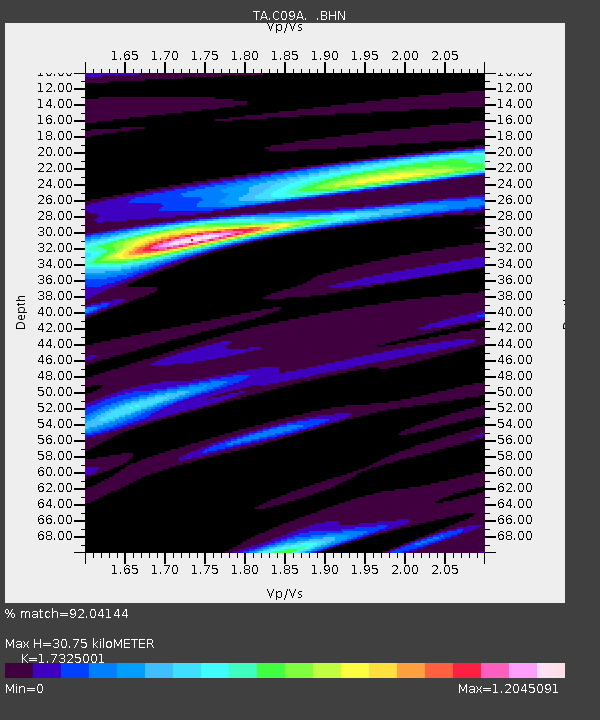
| Estimated Moho Depth: |
30.75 km |
| Estimated Crust Vp/Vs: |
1.73 |
| Assumed Crust Vp: |
6.419 km/s |
| Estimated Crust Vs: |
3.705 km/s |
| Estimated Crust Poisson's Ratio: |
0.25 |
|
| Radial Match: |
92.04144 % |
| Radial Bump: |
374 |
| Transverse Match: |
72.73004 % |
| Transverse Bump: |
400 |
| SOD ConfigId: |
2504 |
| Insert Time: |
2010-03-06 09:37:03.080 +0000 |
| GWidth: |
2.5 |
| Max Bumps: |
400 |
| Tol: |
0.001 |
|

Signal To Noise
| Channel | StoN | STA | LTA |
| TA:C09A: :BHN:20080416T06:01:10.49899Z | 5.7925096 | 6.975552E-7 | 1.2042366E-7 |
| TA:C09A: :BHE:20080416T06:01:10.49899Z | 1.5166552 | 1.9170656E-7 | 1.2640089E-7 |
| TA:C09A: :BHZ:20080416T06:01:10.49899Z | 3.9854012 | 3.2549795E-7 | 8.167257E-8 |
| Arrivals |
| Ps | 3.8 SECOND |
| PpPs | 12 SECOND |
| PsPs/PpSs | 16 SECOND |


