You are here: Home > Network List > TA - USArray Transportable Network (new EarthScope stations) Stations List
> Station C09A Chrisman Ranch, Davenport, WA, USA > Earthquake Result Viewer
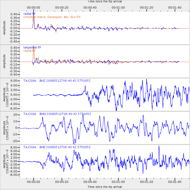
C09A Chrisman Ranch, Davenport, WA, USA - Earthquake Result Viewer

| Earthquake location: |
Sichuan, China |
| Earthquake latitude/longitude: |
31.0/103.3 |
| Earthquake time(UTC): |
2008/05/12 (133) 06:28:01 GMT |
| Earthquake Depth: |
19 km |
| Earthquake Magnitude: |
6.9 MB, 8.1 MS, 7.9 MW, 7.9 MW |
| Earthquake Catalog/Contributor: |
WHDF/NEIC |
|
| Network: |
TA USArray Transportable Network (new EarthScope stations) |
| Station: |
C09A Chrisman Ranch, Davenport, WA, USA |
| Lat/Lon: |
47.80 N/118.27 W |
| Elevation: |
495 m |
|
| Distance: |
93.1 deg |
| Az: |
26.631 deg |
| Baz: |
325.187 deg |
| Ray Param: |
0.04132 |
| Estimated Moho Depth: |
30.25 km |
| Estimated Crust Vp/Vs: |
1.70 |
| Assumed Crust Vp: |
6.419 km/s |
| Estimated Crust Vs: |
3.787 km/s |
| Estimated Crust Poisson's Ratio: |
0.23 |
|
| Radial Match: |
95.50472 % |
| Radial Bump: |
400 |
| Transverse Match: |
91.40058 % |
| Transverse Bump: |
400 |
| SOD ConfigId: |
2504 |
| Insert Time: |
2010-03-06 09:37:10.851 +0000 |
| GWidth: |
2.5 |
| Max Bumps: |
400 |
| Tol: |
0.001 |
|
Signal To Noise
| Channel | StoN | STA | LTA |
| TA:C09A: :BHN:20080512T06:40:42.575005Z | 4.6547313 | 8.7934546E-7 | 1.8891434E-7 |
| TA:C09A: :BHE:20080512T06:40:42.575005Z | 1.0413111 | 2.1972357E-7 | 2.1100664E-7 |
| TA:C09A: :BHZ:20080512T06:40:42.575005Z | 1.2922524 | 2.209384E-7 | 1.7097155E-7 |
| Arrivals |
| Ps | 3.3 SECOND |
| PpPs | 12 SECOND |
| PsPs/PpSs | 16 SECOND |


