You are here: Home > Network List > TA - USArray Transportable Network (new EarthScope stations) Stations List
> Station B18K Kokolik River, AK, USA > Earthquake Result Viewer
B18K Kokolik River, AK, USA - Earthquake Result Viewer
| Earthquake location: |
New Guinea, Papua New Guinea |
| Earthquake latitude/longitude: |
-6.3/142.6 |
| Earthquake time(UTC): |
2018/03/06 (065) 14:13:06 GMT |
| Earthquake Depth: |
10 km |
| Earthquake Magnitude: |
6.7 Mww |
| Earthquake Catalog/Contributor: |
NEIC PDE/us |
|
| Network: |
TA USArray Transportable Network (new EarthScope stations) |
| Station: |
B18K Kokolik River, AK, USA |
| Lat/Lon: |
69.36 N/161.80 W |
| Elevation: |
222 m |
|
| Distance: |
84.4 deg |
| Az: |
17.09 deg |
| Baz: |
235.49 deg |
| Ray Param: |
0.045500048 |
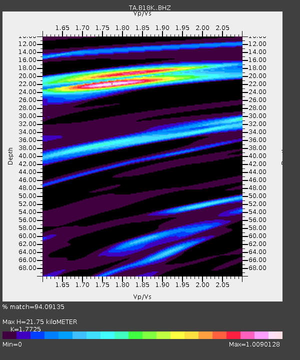
| Estimated Moho Depth: |
21.75 km |
| Estimated Crust Vp/Vs: |
1.77 |
| Assumed Crust Vp: |
5.906 km/s |
| Estimated Crust Vs: |
3.332 km/s |
| Estimated Crust Poisson's Ratio: |
0.27 |
|
| Radial Match: |
94.09135 % |
| Radial Bump: |
400 |
| Transverse Match: |
87.179596 % |
| Transverse Bump: |
400 |
| SOD ConfigId: |
13570011 |
| Insert Time: |
2019-04-29 22:11:43.046 +0000 |
| GWidth: |
2.5 |
| Max Bumps: |
400 |
| Tol: |
0.001 |
|
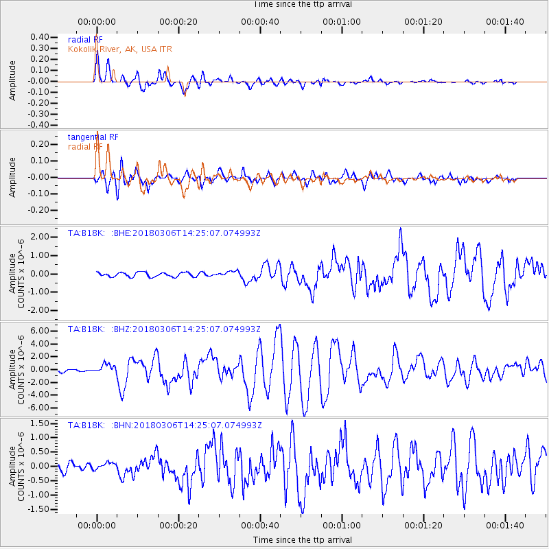
Signal To Noise
| Channel | StoN | STA | LTA |
| TA:B18K: :BHZ:20180306T14:25:07.074993Z | 4.0900774 | 7.3642605E-7 | 1.8005186E-7 |
| TA:B18K: :BHN:20180306T14:25:07.074993Z | 0.7750946 | 1.2774137E-7 | 1.6480746E-7 |
| TA:B18K: :BHE:20180306T14:25:07.074993Z | 1.2665883 | 1.5159733E-7 | 1.196895E-7 |
| Arrivals |
| Ps | 2.9 SECOND |
| PpPs | 10.0 SECOND |
| PsPs/PpSs | 13 SECOND |


