You are here: Home > Network List > TA - USArray Transportable Network (new EarthScope stations) Stations List
> Station C16K Lisburne Hills, AK, USA > Earthquake Result Viewer
C16K Lisburne Hills, AK, USA - Earthquake Result Viewer
| Earthquake location: |
New Guinea, Papua New Guinea |
| Earthquake latitude/longitude: |
-6.3/142.6 |
| Earthquake time(UTC): |
2018/03/06 (065) 14:13:06 GMT |
| Earthquake Depth: |
10 km |
| Earthquake Magnitude: |
6.7 Mww |
| Earthquake Catalog/Contributor: |
NEIC PDE/us |
|
| Network: |
TA USArray Transportable Network (new EarthScope stations) |
| Station: |
C16K Lisburne Hills, AK, USA |
| Lat/Lon: |
68.27 N/165.34 W |
| Elevation: |
102 m |
|
| Distance: |
82.7 deg |
| Az: |
17.215 deg |
| Baz: |
232.204 deg |
| Ray Param: |
0.04668472 |
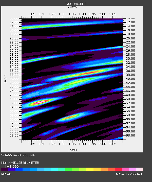
| Estimated Moho Depth: |
51.25 km |
| Estimated Crust Vp/Vs: |
1.70 |
| Assumed Crust Vp: |
5.906 km/s |
| Estimated Crust Vs: |
3.485 km/s |
| Estimated Crust Poisson's Ratio: |
0.23 |
|
| Radial Match: |
94.953094 % |
| Radial Bump: |
329 |
| Transverse Match: |
84.69048 % |
| Transverse Bump: |
400 |
| SOD ConfigId: |
13570011 |
| Insert Time: |
2019-04-29 22:11:42.852 +0000 |
| GWidth: |
2.5 |
| Max Bumps: |
400 |
| Tol: |
0.001 |
|
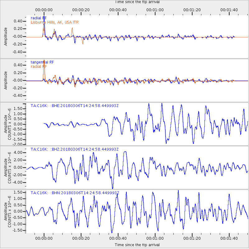
Signal To Noise
| Channel | StoN | STA | LTA |
| TA:C16K: :BHZ:20180306T14:24:58.449993Z | 6.5283923 | 8.6290635E-7 | 1.3217748E-7 |
| TA:C16K: :BHN:20180306T14:24:58.449993Z | 1.3653377 | 2.2588746E-7 | 1.6544439E-7 |
| TA:C16K: :BHE:20180306T14:24:58.449993Z | 2.9335084 | 3.2661015E-7 | 1.1133773E-7 |
| Arrivals |
| Ps | 6.2 SECOND |
| PpPs | 23 SECOND |
| PsPs/PpSs | 29 SECOND |


