You are here: Home > Network List > TA - USArray Transportable Network (new EarthScope stations) Stations List
> Station B22K Teshekpuk Lake, AK, USA > Earthquake Result Viewer
B22K Teshekpuk Lake, AK, USA - Earthquake Result Viewer

| Earthquake location: |
New Guinea, Papua New Guinea |
| Earthquake latitude/longitude: |
-6.3/142.6 |
| Earthquake time(UTC): |
2018/03/06 (065) 14:13:06 GMT |
| Earthquake Depth: |
10 km |
| Earthquake Magnitude: |
6.7 Mww |
| Earthquake Catalog/Contributor: |
NEIC PDE/us |
|
| Network: |
TA USArray Transportable Network (new EarthScope stations) |
| Station: |
B22K Teshekpuk Lake, AK, USA |
| Lat/Lon: |
70.34 N/153.42 W |
| Elevation: |
50 m |
|
| Distance: |
87.4 deg |
| Az: |
17.724 deg |
| Baz: |
243.4 deg |
| Ray Param: |
0.043344393 |
| Estimated Moho Depth: |
11.5 km |
| Estimated Crust Vp/Vs: |
1.60 |
| Assumed Crust Vp: |
5.738 km/s |
| Estimated Crust Vs: |
3.586 km/s |
| Estimated Crust Poisson's Ratio: |
0.18 |
|
| Radial Match: |
93.11783 % |
| Radial Bump: |
400 |
| Transverse Match: |
84.044136 % |
| Transverse Bump: |
400 |
| SOD ConfigId: |
13570011 |
| Insert Time: |
2019-04-29 22:11:43.432 +0000 |
| GWidth: |
2.5 |
| Max Bumps: |
400 |
| Tol: |
0.001 |
|
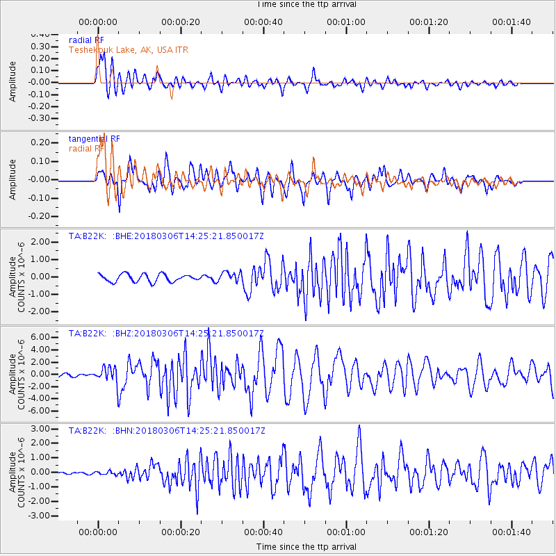
Signal To Noise
| Channel | StoN | STA | LTA |
| TA:B22K: :BHZ:20180306T14:25:21.850017Z | 6.1584587 | 1.3394821E-6 | 2.1750282E-7 |
| TA:B22K: :BHN:20180306T14:25:21.850017Z | 0.5481069 | 1.1447339E-7 | 2.0885228E-7 |
| TA:B22K: :BHE:20180306T14:25:21.850017Z | 1.2915905 | 2.8010535E-7 | 2.1686856E-7 |
| Arrivals |
| Ps | 1.2 SECOND |
| PpPs | 5.1 SECOND |
| PsPs/PpSs | 6.3 SECOND |


