You are here: Home > Network List > TA - USArray Transportable Network (new EarthScope stations) Stations List
> Station C18K Utukok River, AK, USA > Earthquake Result Viewer
C18K Utukok River, AK, USA - Earthquake Result Viewer
| Earthquake location: |
New Guinea, Papua New Guinea |
| Earthquake latitude/longitude: |
-6.3/142.6 |
| Earthquake time(UTC): |
2018/03/06 (065) 14:13:06 GMT |
| Earthquake Depth: |
10 km |
| Earthquake Magnitude: |
6.7 Mww |
| Earthquake Catalog/Contributor: |
NEIC PDE/us |
|
| Network: |
TA USArray Transportable Network (new EarthScope stations) |
| Station: |
C18K Utukok River, AK, USA |
| Lat/Lon: |
68.65 N/161.19 W |
| Elevation: |
845 m |
|
| Distance: |
84.2 deg |
| Az: |
17.811 deg |
| Baz: |
236.128 deg |
| Ray Param: |
0.045656852 |
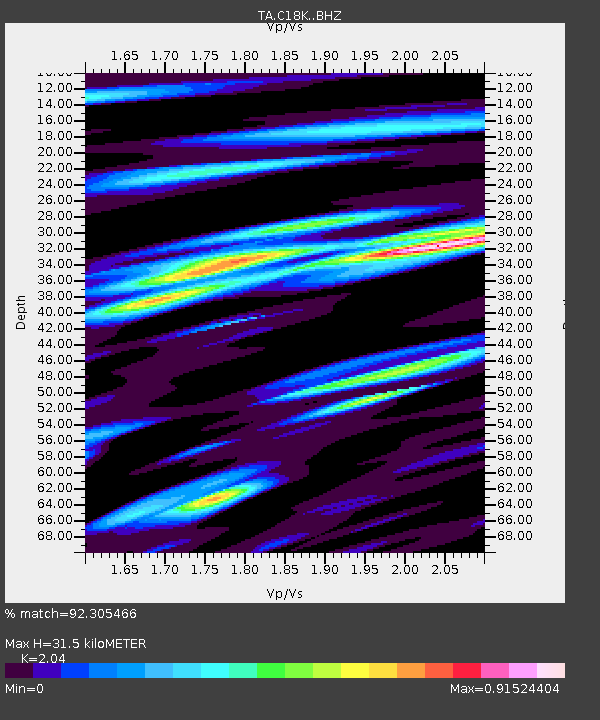
| Estimated Moho Depth: |
31.5 km |
| Estimated Crust Vp/Vs: |
2.04 |
| Assumed Crust Vp: |
5.906 km/s |
| Estimated Crust Vs: |
2.895 km/s |
| Estimated Crust Poisson's Ratio: |
0.34 |
|
| Radial Match: |
92.305466 % |
| Radial Bump: |
400 |
| Transverse Match: |
91.19797 % |
| Transverse Bump: |
400 |
| SOD ConfigId: |
13570011 |
| Insert Time: |
2019-04-29 22:11:47.365 +0000 |
| GWidth: |
2.5 |
| Max Bumps: |
400 |
| Tol: |
0.001 |
|

Signal To Noise
| Channel | StoN | STA | LTA |
| TA:C18K: :BHZ:20180306T14:25:05.949993Z | 9.845792 | 7.683651E-7 | 7.803995E-8 |
| TA:C18K: :BHN:20180306T14:25:05.949993Z | 2.1448033 | 2.345432E-7 | 1.09354175E-7 |
| TA:C18K: :BHE:20180306T14:25:05.949993Z | 1.834544 | 2.156245E-7 | 1.1753575E-7 |
| Arrivals |
| Ps | 5.6 SECOND |
| PpPs | 16 SECOND |
| PsPs/PpSs | 22 SECOND |


