You are here: Home > Network List > TA - USArray Transportable Network (new EarthScope stations) Stations List
> Station G17K Kiwalik Mountain, AK, USA > Earthquake Result Viewer
G17K Kiwalik Mountain, AK, USA - Earthquake Result Viewer
| Earthquake location: |
New Guinea, Papua New Guinea |
| Earthquake latitude/longitude: |
-6.3/142.6 |
| Earthquake time(UTC): |
2018/03/06 (065) 14:13:06 GMT |
| Earthquake Depth: |
10 km |
| Earthquake Magnitude: |
6.7 Mww |
| Earthquake Catalog/Contributor: |
NEIC PDE/us |
|
| Network: |
TA USArray Transportable Network (new EarthScope stations) |
| Station: |
G17K Kiwalik Mountain, AK, USA |
| Lat/Lon: |
65.50 N/160.65 W |
| Elevation: |
338 m |
|
| Distance: |
82.6 deg |
| Az: |
20.585 deg |
| Baz: |
236.946 deg |
| Ray Param: |
0.04675746 |
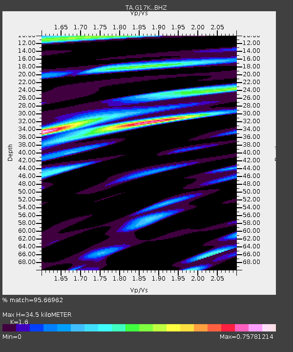
| Estimated Moho Depth: |
34.5 km |
| Estimated Crust Vp/Vs: |
1.60 |
| Assumed Crust Vp: |
6.276 km/s |
| Estimated Crust Vs: |
3.922 km/s |
| Estimated Crust Poisson's Ratio: |
0.18 |
|
| Radial Match: |
95.66962 % |
| Radial Bump: |
400 |
| Transverse Match: |
86.44352 % |
| Transverse Bump: |
400 |
| SOD ConfigId: |
13570011 |
| Insert Time: |
2019-04-29 22:12:14.687 +0000 |
| GWidth: |
2.5 |
| Max Bumps: |
400 |
| Tol: |
0.001 |
|

Signal To Noise
| Channel | StoN | STA | LTA |
| TA:G17K: :BHZ:20180306T14:24:57.925029Z | 7.1073265 | 7.551933E-7 | 1.0625561E-7 |
| TA:G17K: :BHN:20180306T14:24:57.925029Z | 1.1852837 | 2.1360964E-7 | 1.8021817E-7 |
| TA:G17K: :BHE:20180306T14:24:57.925029Z | 2.7948513 | 1.9814607E-7 | 7.089682E-8 |
| Arrivals |
| Ps | 3.4 SECOND |
| PpPs | 14 SECOND |
| PsPs/PpSs | 17 SECOND |


